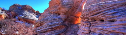
Min-ument Valley: The Topple Blocks of Sand Creek National Natural Landscape Due south of Laramie, where Wyoming meets Colorado, there, or so it seems, is a piece of Southern Utah. It is as if a Utah rock garden has been teleported, spread along five miles of meandering Sand Creek. There are rock chimneys, hoodoos and […]
The Oasis in the Middle of Colorado Springs, CO Location:Palmer Park sits right in the middle of Colorado Springs. There are two entrances to the park. To the WEST entrance: take Fillmore east, just past the major intersection at Union Blvd; you will see some medical office buildings, and then the golf course on the left. Turn […]
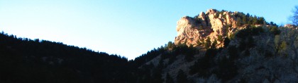
Highlights: A fine spring hike to summit the granite crag overlooking Horsetooth Reservoir, Ft. Collins and the endless plains. During a moist spring, wildflowers are abundant. Location: West of Ft. Collins, CO, about 50 miles south of Cheyenne, WY. Elevations: Trailhead, 5,600’, Top of the Rock, 6,780’. Distance: 1.7 miles one way Map and Guide: “Colorado State Parks: […]
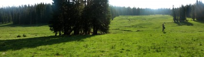
Highlights: This hike is a resplendent walk along the Continental Divide Trail where it weaves together a succession of verdant meadows, each a vast, rich, colorful carpet of wildflowers rimmed with pines, rising and falling along the gentle crest of the southern Sierra Madre Mountain range. Location: West of Encampment, Wyoming in the Huston Park Wilderness […]
New Food for Hikers and Hunters: Pouches is the Word I guess I’m kind of a traditionalist. I’ve been eating the same stuff on the trail and in camp for thirty years. Freeze dried meals. Crackers. Salami. Cereal. Cheese. Some jerky. Raisins. A Snickers bar being the big treat. That is, until last spring. We were mapping […]
BURNING BLISTERS Nothing can turn the Sound of Music into the Batan Death March faster than blisters. The sure footed hunter or hiker can be reduced to a tender foot, limping, hobbling home. The scientific formula to produce a blister goes something like this: Friction + Pressure + Heat + Moisture + Tenderness = Blisters. In other […]
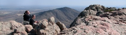
Highlights: A short, pleasant, early season jaunt to the top “tooth” of this Front Range hogback, giving generous 360 degree views of mighty peaks, great plains and deep blue waters. Location: Just west of Ft. Collins, Colorado. Elevations: Trailhead at 5765`, Horsetooth Rock, 7256`. Distance: Approximately 5 miles round trip, about a 3 hour walk. Guides: Larimer County’s “Horsetooth […]
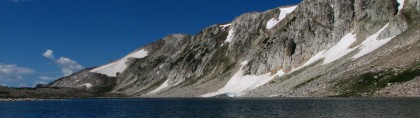
Highlights: It’s the season for a foray into the Snowy Range, the high country of the Medicine Bow. This trail takes day hikers through the gap between Medicine Bow Peak and Browns Peak, past several crystalline lakes into the expansive tundra behind the range. The fish are jumping and the flowers are high. Location: The high […]
Highlights: A walk across the length of the 1st Wilderness Area in the Medicine Bows, established in 1978. The trail passes through three distinct areas. The first is through one of the few remaining old growth lodgepole forests in the area with huge trees and a park-like savannah in between. The second crosses some large […]
Highlights: A mountain trail that follows the spine of the Sherman Mountains, traveling through conifer forests and open meadows, passing rugged rock formations with frequent expansive views. Location: Near the summit rest area of I-80, on the eastern side of the Pole Mountain Unit of the Medicine Bow National Forest. Elevations: Summit Trailhead 8689′, high point 8856′, […]