Sand Creek National Natural Landmark
The information in this piece may be out of date. I have moved away from Cheyenne and am no longer maintaining this site. You may leave a comment if you wish. Useful comments will continue to be posted.
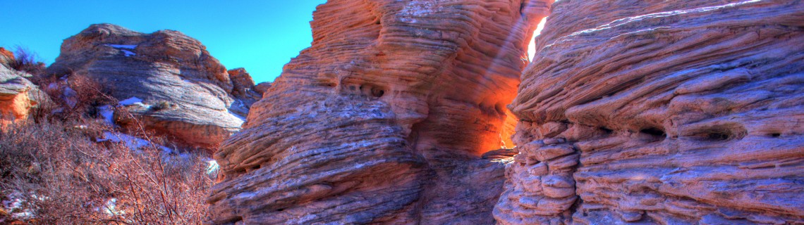
Min-ument Valley: The Topple Blocks of Sand Creek National Natural Landscape
Due south of Laramie, where Wyoming meets Colorado, there, or so it seems, is a piece of Southern Utah. It is as if a Utah rock garden has been teleported, spread along five miles of meandering Sand Creek.
There are rock chimneys, hoodoos and towers of rust and mauve, capped with swirls of grey. Red walled cliffs curve above the sage. At the end, just into Colorado is a great butte, called “Chimney Rock” in Wyoming because from Wyoming it looks like a great chimney, but called “Camel Rock” in Colorado because from within Colorado is looks like a huge crouching camel. It soars skyward 200 or more feet.
Desert grasses and yucca sprout from the sand, blown in ripples. Hawks and eagles call from their homes high on the rocks.
It is unique. In fact so unique that in 1984 the Secretary of the Interior William Clark, under Ronald Reagan, declared these 5,117 acres a National Natural Landscape, one of only six in Wyoming.
I bet you didn’t even know about it.
Minu-ments?
Now these are not the monuments of Monument Valley or the Red Cliffs of Moab. They are smaller, min-uments perhaps, yet still impressive. Nor are they money-mints as Edward Abbey called our National Monuments, with their fee stations. You can visit them free of charge. But only a small portion is public land so most must be enjoyed from your car. Yet that public portion, a half mile square of Wyoming trust land, is worth a wander.
While National Parks, National Monuments and National Forests are all owned by the “nation,” National Natural Landscapes are typically on private or state land or have a mix of owners. They are designated to “encourage and support the voluntary conservation of sites that illustrate the nation’s geological and biological history, and to strengthen the public’s appreciation of America’s natural heritage,” according the NNL brochure.
The National Natural Landmarks (say that three times fast) web site states that “Sand Creek possesses the most spectacular examples of cross-bedded sandstone and ‘topple blocks’ in North America.”
These sandstones are petrified dunes, the sand laid by wind, with layers of deposit (the beds) clearly etched by erosion. The sand was blown one way, then another; troughs formed and were filled, creating layers at different angles, different directions. These beaches of Albany County are old, before the times of the dinosaurs, when huge insects flew about and the first amphibians crawled from the waters.
More recently the waters of Sand Creek and our relentless wind have exposed these ancient dunes and carved them into their unique formations. Cap rocks of grey limestone, many looking like huge cow pies, have kept them from being completely eroded away.
Photographers take note. The National Natural Landmarks program has an annual photography competition that may interest you. For more info see http://www.nature.nps.gov/nnl/.
Getting there…
From Cheyenne there are two ways to go, the short and scenic and the longer and surer. Let’s do the sure route first, about an hour and a half drive.
Take I-80 to Laramie, exiting at 3rd Street/US 287 South. Just across the railroad overpass turn right, and then left paralleling the railroad on Fort Sanders Rd. You are headed toward the Mountain Cement Company. Turn right as if you are going into the Cement plant but stay on Sand Creek Road (CR 34) instead. It is well-graded gravel. Past Hutton Lake the road will angle to the left. The National Landscape begins one mile past the junction of Sportsman Lake Road (CR 316).
The state land begins just as you cross a cattle guard and see the sign “Chimney Rock Ranch” on the right. On the east of the road the public land extends a mile further east and ½ mile south from this corner. There are no roads on this section so motor vehicle use is prohibited. Nor are there any trails.
In fact the soil itself is very fragile and should be trodden with care, stepping where possible on bare rock or pure sand. The dark crusts on the soil are crypto-biotic communities, hidden-life colonies where bacteria, algae, fungus, lichens and mosses live in symbiotic harmony, stabilizing the soil, retaining moisture and pulling nitrogen from the air to fertilize the ground. One footprint may take 100 years to heal.
Be sure to leave fence gates as you find them, respecting the state leaseholder. A map of the area with the public lands identified is found with the photos at the end of this post.
To see the rest of the “National Natural Landscape,” continue south on Sand Creek Road, crossing into Colorado for about a mile. Camel Rock is unmistakable.
The short and scenic route should only be attempted when the roads have had time to dry. Four-wheel drive is preferred. Take I-80 to the Vedauwoo exit, going left toward Ames Monument on CR 234. After 1.3 miles, before the Monument turn right on Hermosa Road (CR 222). After 8 miles you will cross the railroad and reach US 287 at Tie Siding. Go right on 287 for 1 mile, then left on Sportsman Lake Road (CR 316). Continue for 13 miles rounding Boulder Ridge until you reach Sand Creek Road (CR 34). Turn left. At two miles you will cross a cattle guard where you’ll see the “Chimney Rock Ranch” sign.

Comments
Benita Thompson
Aug 15, 2014
Have lived in Wyoming a long time and did not realize that this beautiful area existed. I plan to go see for myself and enjoy the spectacular scenery .
Kevin
Aug 25, 2014
Cool trip report. I appreciate your knack for getting to the bottom of these things. I have never heard of that type of public land designation until you posted this report. you seem to be full of information and opportunities. Have you seen the bonney and bonney white book where they mention camel rock? In the same section, they mention the king and queen and some other hoodoos (I think that is what you are referring to?) off of 287 by sportsman lake road, but on the east side of the hwy. You can see the features from the road. At the time of writing, it seemed to be accessible, but I do not think that is the case now. Are you familiar with these features? They also mention some rock climbing off of 287, in the current location of the 2 bars 7 ranch, and you have to pay to access. have you ever explored this ranch area?
Sandee Carroll
Dec 16, 2014
Spent a lot of time on the Wooden Shoe Ranch, owned by my aunt and uncle, when I was young. We rode horses in this area. It’s spectacular!
Steve Grabowski
Oct 8, 2016
My great-grandfather, Nicholas Lundquist built the Wooden Shoe Ranch, beginning in 1882. My grandparents, Bill and Edith Wurl, were friends with the Marshes, who owned the ranch later on (the Wurls owned the small ranch just North of Chimney Rock.) (See ranch area pictures in my website, http://www.WesternPhotography.com
Cathy Boyd Selby
Mar 13, 2018
We only lived in the area a “short” time as history goes, but it was my formative years. Played in those rock formations with the Lilley kids for HOURS. We lived on Spring Creek Ranch, west of Wooden Shoe about 2 miles, from 1957 through fall of 1963. My sister Barb had the Sand Creek School, on Wooden Shoe, reopened for her to start school in the fall of 1958. She was the only student that first year. Mom and I took a memory trip the summer of 2016 and OH, the memories. My folks were Robert and Darlene Boyd.
tom cowhick
Jun 16, 2020
In 2005, I was a sales manager for a metal shingle panel manufacturer. I got a lead for possible replacement of the roof on the Wurl ranch buildings. I connected with the owner, or perhaps a man who leased the property for grazing cattle. To my delight, he proposed a drive to the ranch on the spot. His cow dog “Spike” and I accompanied him from north of Ft. Collins all the way up to the ranch late that afternoon. I took photos and even a couple short videos as we strolled the range and looked at the house and outbuildings. I never recovered notes I made of the meeting and so I don’t know his name. But I do have a old digital file of snapshots of him and even his own narrative in one video about the quality of grazing black angus on the ranch. I’d love to share them with you sometime. For credibility, I could send poor quality snapshots I took of summer cowpunchers’ graffiti on the plastered ceiling of the main house’s attic_one of which was dated 1916. Another is an Indian Head sketch by a guy from New York.
Dicksie Knight May
May 4, 2015
Many of these rocks are on the ranch I was raised on, plus two branches of my family homesteaded near Chimney Rock in Wyoming and Larimer County, CO. I am a historian in Albany County, Wyoming, and I manage a Facebook page regarding one of my projects, Ranch Histories of Albany County, WY. My Facebook page is as follows: https://www.facebook.com/AlbanyCoRanchHistory?ref=hl
Dave Frendewey
Oct 23, 2015
I used to hike and climb around what we called Camel Rock in the late 1970’s with my fellow University of Wyoming Biochemistry graduate students Bob Geahlen, who first took me there, his wife Marietta Harrison, Sandy Burkhard, Jay Czarnecki, and Jim and Martha Owens.
I haven’t been there in 35 years, but I remember it as a spectacular, isolated western landscape. The pictures bring back fond memories.
Thanks.
Gary Keefer
Jun 11, 2016
We have been by Camel Rock many times, and just across the road and to the east is some old buildings. They are very close to the road, so was wondering if this was a town, stage stop, etc.? Any info on this would be greatly appreciated.
Roger Ludwig
Oct 10, 2016
You asked about the buildings just north of Camel Rock. A recent comment may have the answer to your question. Go to the AwayFromTheGrind.com and look at the comments at the end of the Sand Creek post. I think it must be the site of the Wurl Ranch. The cabins continued to be used by descendants of the family. Roger
Steve Grabowski
Oct 8, 2016
Also, on top of the cliffs, at the hole known as the “Lion’s Den”, are the signatures of some of my ancestors, dating from the late 1800’s. My grandfather also left his mark on Chimney Rock in the early 1900’s. My family ranched a couple of miles south of Chimney Rock starting in 1879, and 1/4 mile north of Chimney Rock starting in 1932 (that’s our place on both sides of the road in front of the big cliffs.) It’s because of the stunning beauty of this place (where I spent all my summers as a child) that I am now a nature photographer. You can see a lot of photographs of this area in the Colorado and Wyoming pages of my photography website below (and the related facebook page.) Also, here is a website about the Wurl Ranch (where I spent summers with my grandparents), which you can access at:
http://www.westernphotography.com/ranch/
Buck Graybill
Mar 25, 2017
Thanks beautiful area would like to know more
Dicksie May
Jul 15, 2017
Love this area where my family had 3 homesteads and ranches.
Karen Rasmussen Hall
Oct 30, 2017
Have been going to the Sheep Creek and Sand Creek area since I was a child. Now my grandchildren are visiting the area.
I have been doing some history research on the Wooden Shoe. Does anyone one know if this ranch was ever used as a mail stop for the Overland Trail?
I was once told, as a child, that there was a mail route from Glendvey up through the area. I haven’t found much info yet, but have only been researching for a couple months.
The area is beautiful and I get there about six times a summer and fall. Maybe more now that I am retired. Thanks for any info or direction to other resources.
Doug (Tex) Bridges
Jun 29, 2018
As a guest at the Wooden Shoe and later a part
time hand from about 1948 through about 1952,
I recall a lot of fond memories from those years
on the ranch and surrounding area. Among my
chores was to wrangle the milk cows from the
west pasture, gather eggs from the barn and
“shop” area, clean buildings of cow dung, crank
the milk separator, etc.,etc. It was a great life
for a city kid of 11 to 15 years. I earned room
and board plus a dollar a week salary for the
movie in Laramie if we went to town on Saturday
Nights, as we often did.
Fran Marsh once mentioned in conversation the
ranch was once a stage stop between Tie Siding
and Woods Landing. Very possible I suppose.
I still remember Oscar, Fran, Woody (hired hand),
Zora, Rhoda Mag and especially Ann, who was the first girl (lady) I had a super crush on. (Wonder
how her life went?) Quite well I’m sure.
I would sometimes accompany guests or just for
fun ride my horse (Tex, and also my nick-name)
to chimney rock for a 10c cold pop. Grape was my
favorite. Then ride the back way through the
rocks and along the creek to the ranch. Super
fun especially if we could race the horses.
(Oscar wasn’t along.) This was about the only
way to get into trouble. A lot of stories and
exciting times come to mind, but that is for
another session.
Steve Grabowski
Oct 7, 2018
Howdy, Tex!
Well, if you bought a cold soda at Chimney Rock, you bought it from my Grandma, Edith Wurl (or possibly one of my cousins, probably Ronald or Leland.) From about 1956 on, I was the pop salesman in the summer. Grandpa was unfortunately disabled, and was less likely to have sold it.
And yes, the Wooden Shoe was a stop on the trail to North Park way back in the 1880’s. I’m told that the stagecoach was pretty much a thing of the past after the railroad got out here in 1868, though. (The Overland Trail came up from Ft. Collins to Laramie and beyond, and the spur cut off around Tie Siding and went west by the Wooden Shoe.) At that time, it was the Lundquist Ranch, built by my great-grandfather, Niklaus Lundquist (sometimes spelled Nikolas.) My grandmother Edith Lundquist Wurl (whom I already mentioned) was born when they lived there, and the original house is the little one that’s out near the county road. She told me a few tales about the ranch in those days.
Lon Van Vorous
Oct 5, 2018
There is a side of me that almost doesn’t want to say anything but as a child my parents took me up here when I was a kid 62-65. I remember it fondly. The Lion’s Den was also a site where Indians ran buffalo into the pit to kill them.
Steve Grabowski
Oct 7, 2018
Hi, Lon…
I lived at the ranch that’s there along the road near the Lion’s Den. My grandma (who lived in the area since 1885) told me the reason for the name “Lion’s Den) was that a mountain lion got stuck in the hole and couldn’t get out. Folks also couldn’t get it out alive, so they shot it, and she said it was hanging on someone’s wall over on the Laramie River (and it measured 8 feet from tip to tail!)
Have you also heard of the “Animal Trap”?
Lon Van Vorous
Oct 8, 2018
My Parents owned 35 acres about 5 miles south of Tie Siding on the far North edge of Colorado. (More summer home than actual living place) The trips we would take up to the Lions Den were with the Cub Scouts. But I do remember stopping in for a soda on the way home and getting permission to be on the property at the ranch. We also did arrow head searches out by some small stock pond in the area. No I’m not sure I’ve heard about the animal trap.
Andrew Smith
Apr 1, 2019
Hello
I know about the Animal Trap! I own the parcel of property where the animal trap is located. It is pretty cool. Tons of carvings from the Homesteaders – Wurl family, Honzhole’s (sp?) family and many, many others. The oldest carving we have located so far is from 1890 – but only initials no name. We also find lots or Native American Artifacts. Five years ago we had the dean of Archeology from Colorado State visit the property and took pictures as well as dated some of our spread and arrow heads. He said some of the arrows heads we found were 3-4 thousand years old. Crazy! The Native American did not use the Animal Trap to trap Bison. They used the Animal Trap to capture and kill predators for there soft fur hide as buffalo hides were very abrasive and scratched their necks and arms. So they used the predators fur for around end of the sleeves and neck area to prevent the abrasive rubbing on skin. How they lured the predators into the Animal Trap was by throwing all unused or bad meat and bones from buffalos they ran off the cliffs into the animal trap. Once the predator jumped in, they were trapped and easy to kill from above. The Native American’s knew trying to kill a bear, mountain lion or wolf was pretty tough and dangerous with just a rock spread head, so they trap them in the Animal Trap instead. The other cool fact is a major archeological dig was conducted in the animal trap in the 60’s. They archeologists found 37 different vertebrate bones, including a 12 thousand year old lion jaw bone. The Archeologist said the lion looked like something you would see in Africa today but much bigger I would assume. Our family is also convinced the area is haunted as we have seen everything from sparkles in the rocks, the glow orbs and even full apparitions. My son at 5 years old said he saw an Indian Chief sitting on the rocks watching us. Which was crazy to hear from a child so young. So if anyone knows, if someone has died up there or any history about the cliffs directly across from Chimney Rock (aka Camel Rock) please let me know, I would love any details/information.
L G Martin
May 3, 2019
Chimney Rock, Camel Rock has also been known through history as Sitting Hen and Sand Creek Sphinx. Lions Den or Animal Trap is also known as The West Trap in different history books with another similar although larger East Trap located south of Laramie in the area known as Red Buttes. The East Trap has many names and dates carved into the South Wall of the trap by Cavalry soldiers from the mid to late 1800’s who were in the area to protect travelers on both the Overland and the Cherokee Trails. The Cherokee trail separated from the Overland trail about where Tie Siding is located, continuing west till it rejoined with the Overland trail near Walcott. I also spent a lot of time in Sand Creek Park when it was known as the Chimney Rock Ranch when Frank Lilley managed it. I then purchased land 1+ miles south of Chimney Rock after the began selling the Colorado side off. I still own 210 acres of it to this day with a fabulous view of Chimney Rock and the Cliffs, and yes there are two known historic buffalo jumps located there. I have a very well preserved skull that we uncovered from the bank of one of my ponds and another skull plate and horns also found there. These skulls are quite a bit larger the the modern-day Bison. I have also found many artifacts in the area dating as far back as the Plains View era, 8,500 years old. Until about 30 years ago this area was the best kept secret Nature had in this area.
L G Martin
May 3, 2019
Chimney Rock, Camel Rock has also been known through history as Sitting Hen and Sand Creek Sphinx. Lions Den or Animal Trap is also known as The West Trap in different history books with another similar although larger East Trap located south of Laramie in the area known as Red Buttes. The East Trap has many names and dates carved into the South Wall of the trap by Cavalry soldiers from the mid to late 1800’s who were in the area to protect travelers on both the Overland and the Cherokee Trails. The Cherokee trail separated from the Overland trail about where Tie Siding is located, continuing west till it rejoined with the Overland trail near Walcott. I also spent a lot of time in Sand Creek Park when it was known as the Chimney Rock Ranch when Frank Lilley managed it. I then purchased land 1+ miles south of Chimney Rock after they began selling the Colorado side off. I still own 210 acres of it to this day with a fabulous view of Chimney Rock and the Cliffs, and yes there are two known historic buffalo jumps located there. I have a very well preserved skull that we uncovered from the bank of one of my ponds and another skull plate and horns also found there. These skulls are quite a bit larger than the modern-day Bison. I have also found many artifacts in the area dating as far back as the Plains View era, 8,500 years old. Until about 30 years ago this area was the best kept secret Nature had in this area.
Karen Hall
May 11, 2019
Love hearing the history of the area. Would like to know more. I am a history geek. If possible maybe meet people that still live in the area. My late husband’s uncle owned two properties on Bull Mountain back in the early 90’s. I have been going to the Sand Creek and Sheep Creek area for 60 years with my family, hunting, and then my husband and sons, hunting. Love the area,so beautiul and peace full.