Guadalupe Mountains National Park: Finding Spring
The information in this piece may be out of date. I have moved away from Cheyenne and am no longer maintaining this site. You may leave a comment if you wish. Useful comments will continue to be posted.
Spring rarely visits Cheyenne, Wyoming during spring break. So if we’re to truly have a spring break we have to go find it. Where can we find new leaves unfurling, smell the fragrance of wildflowers and walk in a t-shirt, even sweat in the heat of the sun? Here’s a good place, within one long day’s drive, to find spring the last week of March: Guadalupe Mountains National Park, Texas.
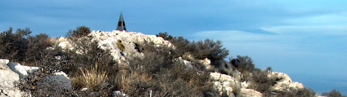
Mountains in Texas? I didn’t believe it at first either. But there are mountains in Texas just over the New Mexico line. Guadalupe Peak, the highest point in Texas, at a height of 8,749 feet, rises 3,000 feet from the canyon floor. (For comparison, Medicine Bow Peak is just 1,600 feet above the glassy surface of Lake Marie. So, yes there are some mountains in Texas.) And on the top of the peak is the strangest little pyramid, a pointy thing made of stainless steel with commemorative plaques honoring airline pioneers and the postal service. Secretly, I think it has something to do with all those UFO’s honing into Roswell just to the north. But it’s spring you’re interested in, so here we go….
To get there drive as straight south from Cheyenne as you can, 757 miles. I-25 to Romeroville, south to Santa Rosa, through Roswell, down to Carlsbad, turning south on 180 through Whites City (past Carlsbad Caverns), crossing the state line and , kaboom, there they are, rising up majestically from the West Texas plains. Gray and brown, these limestone mountains are the remains of an ancient, saltwater reef. You’re standing on what was the ocean floor, looking up at the work of billions of billions of sponges, crinoids, bryozoans, fusulinids and such who gave their little lives to make this rock back about 250 millions of years ago. But instead of standing deep underwater with strange Permian sharks, you’re in a prairie abloom, bright yellow and fragrant with brilliant bladder pods. (Who ever named these lovely plants was not a poet.) It is spring, breath deep and prepare to sneeze.
It’s worth driving just a little south of the park entrance to see the south facing towering walls of ElCapitan. It was here, at sunset, August of 1583 years ago, that Spanish conquistador Antonio de Espejo rode up in the unbearable heat and dust and saw a vision of Our Lady of Guadalupe on the rock, hence the name. Who knows? You just might see her, too. You’ll certainly see the amazing juxtaposition of life. Surrounding you for miles is the northern reach of the Chihuahuan Desert, with its cacti, chollas, yuccas (and bladder pod). Upon entering the two deep canyons that cut their way into the highlands are a mix of eastern woodland maples, walnuts, ash and oak. Hiking up one of the steep trails that traverse the canyon walls to the peaks and highland floor are the familiar trees of our own Rocky Mountains, ponderosa pines, junipers, and the southernmost reach of aspen. The rangers boast that the Guadalupes hold 900 kinds of plants, 60 species of mammals, 289 species of birds and 55 reptiles and amphibians. This is where east meets west meets north meets south.
There are places in the world where the beauty shouts to be seen. This dry country is not one of them. It’s more subtle. In greys and taupe, the eye searches for color and sees instead texture and pattern. The spiraling patterns of spines on the cactus. The rough, scaling bark of the alligator junipers. It is a masculine land. Not the strong majesty of mountain peaks, but the miserly toughness of a character who, fearing some stranger will take what he has, guards it all with barbs and spines, layers of bark and needle and rock that can cut you like a knife. Yet among the agave there is a striking feminine beauty here, like the miser’s lovely daughters running carefree, hands flung to the sky, fearing nothing. These are the graceful, reaching, Texas madrones. Trees that trust in the shelter of their own evergreen leaves, trusting so freely that they let their bark fall down to the ground, revealing a skin of white, red and even lavender. It’s a skin that begs to be caressed, and when touched is smooth and cool. In late March their leaves are accented with clusters of white flowers, like tiny turbans, releasing a subtle, indescribable scent, loosening our cabin-bound, winter-held souls to the renewal of spring’s promise. The madrones are along the canyon floors, they find a home to tease high on the walls and they sway on the rolling table lands atop. A person could come here just for the madrones.
As your eye adjusts to the feel of the place you’ll begin to see the lizards that scale the rock, looking like shadows or cracks that scurry and stop and scurry on again. Horny toads that blend in with the litter. These 900 kinds of plants are hidden away to reveal themselves only when our mood is right to see.
A good place to start your exploration is the visitor center at Pine Springs. It’s a nice place with friendly rangers who actually are glad to see you, informative displays and good water. The 250 million year old park is a new one by Park Service standards, established in 1972. It covers 86,415 acres, 46,850 of them designated wilderness, with 85 miles of hiking trails, the four highest mountains in Texas (Guadalupe, Bush, Shumard and Bartlett), ten backcountry campsites and two car accessed camping areas, one at Pine Springs and one at Dog Canyon on the other side of the park. There is plenty of room to stumble around.
If you are a backpacker, it’s necessary to get camping permits. They’re free and guarantee you privacy and space. The campsites, except for one, are up high where Texans go to cool off and where you want to go anyway. From Pine Springs you can hike up to the top of Texas, Guadalupe Peak, dropping your pack along the way at the campsite. It’s 4.2 miles and 3,000 vertical feet to that weird pointy little pyramid thing. Last spring, at sundown, I watched a peregrine falcon search, swoop and dive for prey below me. Going the other direction from Pine Springs canyon, up the Tejas trail, you traverse the canyon wall to a network of well-marked trails that cover the heart of the high ground, rolling up and down through the pines, douglas fir and junipers.. You won’t be the first Wyomingite there. Some elk were given a one way ticket from the Black Hills back in 1929. Their great-grandkids are still around.
There is a significant difficulty that I should mention. There is no water in the high country. None. Nada. Zip. The limestone rock drinks it like a kid with a straw in a coke on a hot Texas porch. The rock spills it out far below in a few clear rushing springs on the canyon floors. But the only good it will do you up here is if you brought it with you. A gallon a day is only sensible. So imagine leaving Pine Springs, coming up the trail. Camping at one of the high country sites (Tejas or Mescalero are especially nice). Then down the north side to Dog Canyon where you can refill. You’d need to carry at least one and a half gallons, assuming you’d drink a quart before you leave and when you arrive at Dog. That’s 12 pounds of water. It’s heavy but get used to it. That’s the price of admission to this great place. (By the way, Dog canyon is named for black tailed prairie dogs, which once were plentiful but now have been extirpated. Bringing back prairie dogs to Texas must be like putting wolves back into Wyoming….)
Up in the high country you’ll bump into some tantalizing pipe lines leading to a sadly empty tank. The abandoned remains of a pump system that brought water to the top to quench the thirst of those elk, and of 100’s of angora goats. Rancher J.C. Hunter tried everything to make his ranch pay. So he brought in the goats. They thrived but grew wild as satyrs. And J.C., now that you’ve let them loose, how do you round them up? They ate everything down to the crinoids. When J.C.’s son sold his 72,000 acres to the Park Service in 1966 the men in gray must have had a wild time chasing down the last of them.
While the eastern side is cut with two deep canyons, knife edged walls dropping into the dark abyss, the north and western side is more rolling, opening a different kind of beauty with expanses of golden grass. The Mescalero Apaches made their last stand here against the U.S. Army. They held out for thirty years. It wasn’t until 1881 that the brilliant chief Victorio surrendered to reservation life far to the south. Legend tells, though, of bands of Apaches returning, summer after summer, to shelter in the meadows of Dog Canyon into the 1930’s. Strolling across the meadows in the evening it’s not hard to imagine the smoke from their fires, the stomping of their ponies and the laughter of the children.
Dog canyon is a wonderfully remote place. It takes an hour and a half for the rangers stationed there to drive the 65 miles of mostly gravel to get their groceries and gas in Carlsbad. It’s hard to imagine a more remote Park Service campground in the lower 48. I asked a ranger what he did to get sent here, was it something bad or good?. “Park Service Paradise”, he said as he came back from tending his Government Issue quarter horses. In the spring vultures assemble here, en mass, on their way north. Hundreds of them weighing down the trees is a site. Hundreds circling above you at dusk makes you wonder if you are the dinner guest.
To hike from Dog Canyon back over the top is another overnighter, another 12 pounds of sloshing water, but it leads to a great site on McKittrick Ridge, overlooking the high country to the west and the walls of McKittrick canyon hanging like miles of drapery down below. As I was marveling at the sunset and a curious white cloud shaped like a soaring dove, a black crow shot out from behind me at head level, straight as if shot from a canon, disappearing into the white of the dove far away. It had the portent of an omen. But I would have had to ask the apaches to know for sure. I hoped that it was my bad luck flying away.
The hike down into McKittrick Canyon is a wonderful thing. There is the shear depth, the eroded limestone walls, the madrones of course, and the sight of green below, trees bright with leaves electric with spring. Yucca plants that glow a brilliant green fire in the morning sun. And as you drop toward the floor you can smell it. Flowing water, springing silently from the rock, bringing the sound of song birds up into the air. Fresh leaves uncurling, now you are there, walking along the steam, water clear as crystal. Further along are people coming in for a day hike, reveling in the mystery of this place that many call the most beautiful spot in Texas. The waters pool together, trout lounging safely in the shadows.
A geologist, Wallace Pratt, wealthy with oil, bought this place in the 1930’s for sanctuary. He had a beautiful cabin crafted here entirely of local rock, even the roof. His company went on to become Exxon. And the cabin and acreage? Donated to the enjoyment of the people. It can be your sanctuary now, at least for the day. The canyon is locked at nightfall.
My luck? It remained good as I was given a ride by a friendly Canadian couple back to my car at Pine Springs, 12 miles away.
For day hikers, the Park has many glories. Certainly a trip up to Guadalupe Peak (8.4 mi round trip), and the hike into McKittrick canyon (6.8 mi). Hiking into Pine Springs canyon is fun. It’s a dry canyon, unlike McKittrick, and the stream bed leads to a natural set of wide, curving stairs called, fittingly, the Hiker’s Stairway. Beyond the stairway is the Devil’s Hall, a narrow passage of naturally squared rock (4.2 mi.). (Why does the Devil get so much credit for America’s wild and weird places?) I was told that there are some pictographs if a hiker continues past the trail’s end. You might ask at the ranger station.
There are some interesting historic sites to walk or drive to, including Frijole Ranch and the ruins of a Butterfield Stagecoach station. A day hiker could also ascend the Tejas trail, enjoy the pines and descend through steep Bear Canyon back to Pine Springs (9.1 miles). And there are also desert hikes around the base of ElCapitan.
When you visit the park you should be prepared for the area’s remoteness. The nearest city is Carlsbad, 55 miles away. The nearest gas is Whites City, 35 miles north. The Pine Springs campground (20 tent sites, 18 RV, restrooms but no showers, no RV hookups or dump station, no wood or charcoal fires) is first come, first served, and is likely to be full by afternoon ($8.00 per night per site.) If you are coming in late you may be wise to camp at Whites City and drive in in the morning. You’ll be able to see the big reef rise from the desert that way, too. There is a $3.00 entrance fee per person 16 and over.
If you want to know more call Guadalupe Mountains National Park, 915-828-3521, or look them up on the web at www.nps.gov/gumo. National Geographic publishes a good Trails Illustrated Map (www.nationalgeographic.com) and there is a hiking book by Falcon: Hiking Carlsbad Caverns & Guadalupe Mountains National Parks (www.falconguide.com).
On the way home, stop at LasVegas, New Mexico. Go straight to Charlie’s Spic and Span Bakery and Cafe (www.charliesbakerycafe.com), 715 Douglas Avenue. Load up on the finest brownies, whole wheat tortillas and coffee and you might just truck right on to Cheyenne, with that, and the dose of spring in the Guadalupe’s you’ll be prepared to survive two more months of winter.

Comments
Heidi Kaldenberg
Nov 14, 2018
I love this. Exceptional writing about one of my favorite places! A thorough, accurate, and compelling description. The paragraph about the madrones really made me smile. Thanks for taking the time to pen this beautiful, inspiring tribute to our desert mountains!