I Love Big Bend National Park. It Nearly Killed Me.
The information in this piece may be out of date. I have moved away from Cheyenne and am no longer maintaining this site. You may leave a comment if you wish. Useful comments will continue to be posted.
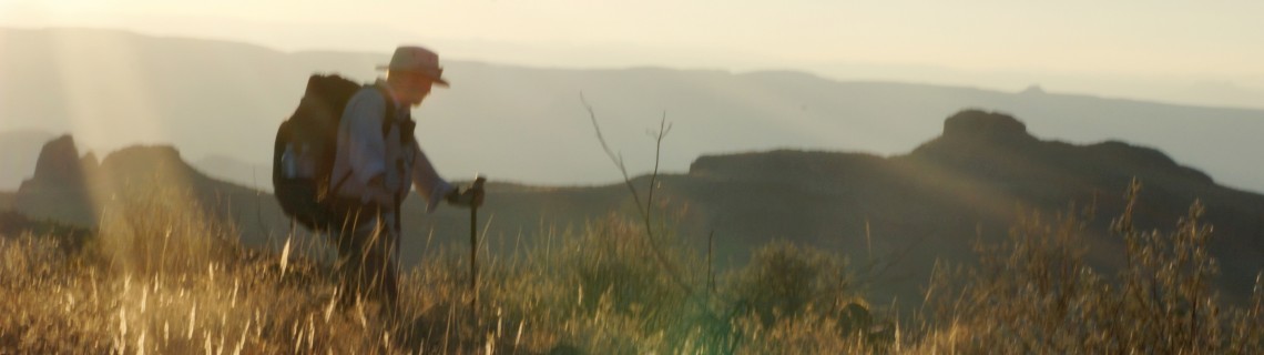
The Chisos Mountains are like blocks dropped from the sky, crowding the horizon with towering edges that jangle the sense of right and wrong. This is southwest Texas, Big Bend National Park, where the Rio Grande, our border with Mexico, takes a turn to the north making the big bend. The Chisos, rising nearly 8,000 feet, support oaks and pines, madrones and junipers, trails and a park village right in their heart, the beautiful Basin.
Below the Chisos to the south are lower mountains and hills, even more rugged, covered chockablock with every manner of cactus and thorn. All with one aim. To poke, pierce and stab; to have you bloodied, running, vowing to never return; to leave them in peace. These mountains are the Sierra Quemada.
Below them the open desert expands and expands even more. Crunchy gravels. Striped badlands. A vast space domed by an endless sky, peopled only by more cactus and scrub, but more sparsely spaced.
Then the river, the Rio Grande, having made its way from the Colorado high country, through New Mexico, turning east as it divides Texas from Mexico, flowing languidly, brown and shimmering, a quiet hush creating a ribbon of verdant green. Our brown lands to the north. Mexico’s to the south.
This is our southern border, so much in the news you would think it would be alive with guards and drones and wire and feverish furtive people wanting to cross to rob us of our livelihood. Utterly quiet. Not a soul. Not a fence. Not a building, shed or shack. Serene. A deep breath of moist air.
This place nearly killed me.
I love Big Bend. It’s warm when Wyoming is cold. And it is wild. The park was created to preserve Texas’ last frontier. And it does.
Here the last mountain of our Rockies rises from the desert. A long ridge, brown and bare as an index finger laid on the ground, Mariscal Mountain is jaggedly cut in two by the Rio Grande, the cut making a wondrous canyon. But on that ridge, walking north, Big Bend tried to do me in.
Not by thorn, or by precipitous drop, or by rocks so sharp they will cut you–although all are there in plenty. Just sun. And exertion. And Advil, according to the physician’s assistant. But that’s for the end of the story.
Big Bend National Park, like our other great parks, has something for everyone.
If you want modest luxury you’ll a fine lodge and delicious food in the mountain fastness. On a budget? Campgrounds for RVs and tents are nearby.
A network of well-marked trails make for perfect day hikes. Rangers are knowledgeable, and especially friendly. Paved roads lead to scenic wonders with informative signs.
For those who want to explore the remote ranges and ruins by four wheel drive this is mecca. And floating the Rio Grande, camping on the sand banks, I’m told, is sublime.
The attraction is the scenery, the wildlife, the botany and the birds. No U.S. Park rivals Big Bend for the diversity of its flora and fauna. It is the northern edge of many Mexican species. And the southern edge of many U.S. ones.
You’ll find deer, both white tails and mulies. Desert bighorn, pronghorns and coyotes, javilenas, black bears and aoudads–Barbary sheep from North Africa. Big hairy tarantulas that don’t bite. Four kinds of rattlesnakes that do but are rarely seen.
Many visitors come for the birds, particularly in spring. More than 450 species have been recorded.
For backpackers there are backcountry camp sites on the south rim of the Chisos. Gorgeous views of sunrise and sunset to be savored with coffee, or bourbon, or both. For more intrepid backpackers there is the “Outer Mountain Loop” which rims the Chisos and then follows a rough trail through the Sierra Quemadas.
For those looking for the epic there is everything else. Remote routes marked only by cairns hidden midst the cacti. And the routes that have no cairns at all.
We were going for the epic.
It was November. The days are short but still hot. More than 90 degrees in the desert. The summer had been a bust for me. Recovering from shoulder surgery—which is where the Advil comes in–I hadn’t done anything to be proud of. Anything to give me the assurance that I can still do something. Something hard, not really fun, but challenging enough to assure me that I am still living. If you know that feeling, you know it. If you don’t, I can’t explain it. It probably borders on insanity. But there are a number of us troubled in this peculiar way.
Shan Holyoak had had a good summer, hiking Oregon, from south to north. But he was ready for one more adventure before the light of 2017 snuffed out. He was born ready, he likes to say.
Our plan was to backpack about 100 miles in six days. We’d start by getting our free back country permit in the Basin, have a humongous breakfast at the lodge and head out, taking trails up and through the Chisos, then down a long wonderful canyon to an old ranch HQ, then off into the wilds of the Sierra Quemada.
We’d climb unmarked Jacks Pass and scramble down to an old ruin by a spring. Then south, leaving the last of the foothills, striding toward the Rio Grande and Mexico. At the river we’d water up and then turn back north, hiking and scrambling our way up Mariscal Mountain. We planned to walk its ridge until it dropped down to an old quicksilver mine.
Then back across the desert, into the Sierra Quemada by Elephant Tusk and the long upward ascent in the Chisos. Maybe we’d summit Emory Peak (at 7,825’ the highest in the park) before making the descent back to the car and a celebration steak dinner.
It was a plan. It had been done before. The intrepid Benders at Big Bend Chat who know all of the springs confirmed that our plan for water was sound if a bit adventurous. Leaving Cheyenne at dawn, we made it to Big Bend by 9:00 pm.
All went well to start. The Chisos are beautiful. The canyon both curious and lovely. We spotted trouble when we came across a young backpacker who was suffering heat exhaustion and dehydration. A ranger was tending to him. It was in the 90’s.
At remote Smokey spring we came through flowering shrubs covered by butterflies, three kinds, dancing in the air around us in the thousands. The night skies were alive with stars, the Milky Way a river of light. Meteors cut the sky like a saber slash.
Before dawn on day three we started through the desert. The sun rose to our left, climbed overhead and made its descent to our right. We had not stepped out from its single-eyed glare all day. Not a spot of shade to hide in.
The desert rocks hold and then release the heat. It’s like being on an immense stove top in the sun. Heat from below, heat from above. But we were well watered, sipping down our six quarts, metering it to end as we reached the river.
It was an experience.
I knew something wasn’t right when I had no saliva and couldn’t get food down. But we made it to the river, cooling my feet and head, refilling our bottles. I felt better and we started off for the mountain.
In camp that night I couldn’t eat. With no saliva to break down food it just wouldn’t swallow. Did drink some instant breakfast. But by morning I felt better, ate some, and we hoisted our packs. We ascended the trail,viewed the canyon from above, then left the trail to make our scramble to the top, almost 2,000 feet above the river. It was hard, precipitously exposed. An endless cactus garden. And a mistake.
As we began our long haul along the ridge, winding in and out of drops and rises, I was getting weaker than I had even been. No headache, no fever–but limp, a puppet with slack strings. While resting we knew I was in trouble. If I was this bad now I wouldn’t get better without real rest.
The plan was off. But we had to get down to a road somewhere.
I felt no fear. And learned something. To have anxiety requires energy. So without energy I had no anxiety. Placid calm. But I fantasized cool. Lounging in a swimming pool. Laying naked on a cold concrete floor.
Shan challenged me. He calmly explained the obvious. We had to get off this mountain by dark, by 5:00. We had five miles to go. I charged up, somewhat random and wasteful but motivated on in the generally right direction.
At 4:00, after a long rest in the shade of a big rock I pulled myself up on my trekking poles to slowly follow Shan’s steps as he guided me. One more big up and then down. We camped by the road near the quicksilver mine. It was dark. The wind tore at our tents. Harsh but blissfully cold.
At dawn we inventoried our water. We had 8 ounces each. Shan planned to hustle six miles along a dirt road to the river for water. I could do nothing but sit in the roofless shade of an old concrete house and hope for visitors.
While he was gone on his Herculean task to keep us alive in case no one came I dozed. The hallucination was lovely, the air filled with sparkles, like specks of mica everywhere afloat. I blinked. They were still there. Smiling, I took a tiny sip of water. The morning drifted on.
It was nearly noon when the dirt bikes roared in, the thundering sound of petrochemical salvation. The driver of a jeep gave me water and drove off to get a ranger. The water was delicious. Shan came marching up, toting twenty pounds more of water. We sat in the shade. He had just trekked 12 ½ miles. I owe him a lot.
Midafternoon a ranger pulled up, all patience and courtesy, and let us in to the world of air-conditioned Dodge comfort. I was embarrassed. In forty odd years of hiking I had never not walked out of something I walked into. We began the long drive back to the car, then to a motel, then to Cheyenne.
I was feeling OK but still weak. The physician’s assistant at the urgent care clinic heard my story, took some blood and had me pee in a cup. My kidney numbers were way off the norm. Liver wasn’t great either. What meds did I take? Only Advil, according the shoulder surgeon’s orders, 1,800 milligrams per day, for the past 30 days. He had told me to take even more than that.
I learned that Advil, at that dosage over that period of time, restricts the flow of blood into the kidneys. With the exertion and the heat my blood was a toxic. It wasn’t being filtered. Stop the Advil, she said, now. Check with your family doctor in a week.
So I did and was getting better.
So what about Big Bend?
Shan went back in January to complete the plan. I was just getting my strength back. No way was I going. But he did, and did finish our plan with some variations, avoiding the Mariscal ridge. The backpack from the mine was really hard, he said grimly. And the route finding a challenge. But Shan is not someone to leave a task undone.
You should go. Long ago I found that three things are necessary to get through a Cheyenne winter.
Find something to do outside, like snowshoe, ski, ice fish or snowmobile. Learn to enjoy “cozy,” what the Danes call “hygee,” curling up in a chair, sipping something and praising the fire while the wind tears the trees apart outside. And third, get away to someplace warm.
My friends who golf go to Phoenix. My friends who lounge go to a beach in Mexico. But what about those who hike, who love mountains and dirt and nature in the raw? There is Big Bend. Just go easy on the epic.
When you go…
Big Bend National Park is in Southwest Texas, 950 miles south of Cheyenne. It was established by Franklin Roosevelt in 1944. The Park is big. Three Rocky Mountain National Parks would fit within it.
- Hiking Big Bend National Park: A Falcon Guide
by Laurence Parent is a handy guide. Trails Illustrated Map “Big Bend National Park” is good for the roads and trails.
By all means review the Park Service’s excellent web site at www.nps.gov/bibe. If you are considering a backpack on the Outer Mountain Loop or anything off-trail, study the trip reports and chat with the good volunteers at www.bigbendchat.com.

Comments
Jana
Jul 9, 2018
I’m looking for a good 7 day backpacking trip in the area you’ve described in your post. We like to hike around 10 miles per day, which is less ambitious than yours.
Can you point me to resources that would help to cobble that together? The Outer Mountain Loop sounds great, but not long enough for our desired time out.
We are experienced backpackers in both heat and cold. We’ve backpacked the grand canyon in January – which is the same month we’re aiming to do this trip.
Roger Ludwig
Jul 10, 2018
I don’t know Big Bend well enough to advise you. I’d suggest studying the Trail’s Illustrated Map of Big Bend by National Geographic, and perhaps look at the Falcon Guide and see what may interest you. Then log in to Big Bend Chat and run your ideas by the folks on the blog. I think they’ll give you good advice. Best wishes. It is an amazing place.
LE
Nov 17, 2019
I loved your story. I hope to go with my daughter one day . . .
Ralph J Yehle
Feb 13, 2020
Emory Peak is not the 2nd highest in Texas. But still worth the climb. Stay off those drugs if you are out hiking.
Roger Ludwig
Feb 17, 2020
Hi Ralph – thanks! Got that corrected! The highest in the park. According to Wikipedia it’s 14th in the state, with 11 of those in the Guadalupe Mountains and 2 in the Davis Mountains.
Donna Wynn
Feb 13, 2020
Thank you for this incredible story and beautiful pictures. Big Bend has been in my soul for the past 40 years and still my favorite place to be.
Merry
Feb 15, 2020
It was the Tylonel that almost killed you, not the trail! Funny how these meds don’t have any warnings on use!
Rob
Feb 16, 2020
Loved the story. Thanks for sharing. One tidbit… Emory Peak is not Texas’ 2nd highest peak… I believe it is 5th.
Roger Ludwig
Feb 17, 2020
Thanks Rob! Got that corrected! Roger
GaryF
Jan 26, 2022
I’m just back from a 5 day backpack in the park, and your story really hit home. I take ibuprofen on the trail to help with aches and pains, and I took 20 tablets, 4000 milligrams, over the course of those 5 days. It’s something I need to be aware of, thank you for sharing it!