Hewlett Gulch
The information in this piece may be out of date. I have moved away from Cheyenne and am no longer maintaining this site. You may leave a comment if you wish. Useful comments will continue to be posted.
The word “gulch” brings up scenes from a cartoon. A dry desolate wash, complete with a bleached cow skeleton, where (gulp!) our intrepid hero Goofy is about to be dry-gulched by a gang of stubble-faced villains.
Not an inviting picture. And nothing like Hewlett Gulch.
Hewlett is an inviting ramble up a pleasant creek, a little valley off the Poudre River canyon that is one of the first to take hold of spring and keep it. It’s good for a spring or fall walk, run or a mountain bike excursion.
Just out of the parking lot the trail winds through groves of cottonwoods that ring with bird song. Without really looking you’ll see robins, flickers, gray “camp-robber” jays and their mountain jay cousins, plus nuthatches creeping up the bark.
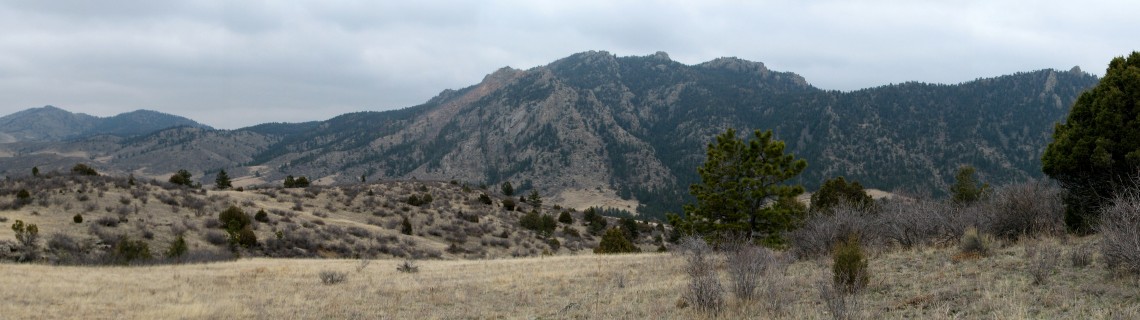
It’s open and sunny with scattered pines and junipers midst the tall grasses and rabbit bush.
This spring I was on the search for pasque flowers. Passover was past and Easter was the next day and I hadn’t seen any. Named for the holidays because they raise their heads from the cold ground during the season, shyly cloaked in purple, purple the color of the church linens of Lent. It just didn’t seem right to celebrate the resurrection without them.
Besides I love walking along a playful creek. Makes me happy. Some say it’s the negative ions that moving water generates. There’s science that supports the notion that these ions will improve mood and even speed healing.
Maybe so, but it might just be the pleasant chatter of the creek, babbling about how good it is to be out in the sun and free from the cover of ice and snow.
The Trails
The first stretch of trail, the official one which runs north from the Poudre river for about three miles, sees plenty of the creek, Gordon Creek that is, wandering back and forth, crossing it some eighteen times. The elevation rises gently, a total gain of 570 feet. The Forest Service rates it “easy”, and it is unless all the stepping stones unnerve you. In that case a walking stick may be nice.
At the start the route passes the foundations of four old cabins. These were built by the Spaulding Family who lived here from 1922 until the 1960’s. Frank and Ada Mae came first, had ten children, some of whom married and stayed on. It’s a pleasant daydream, imagining life here, raising strawberries and milk cows. I think you’ll find some lilacs carrying on.
Around the ruins I found clusters of my sought after pasque flowers, sticking together for warmth or love, showing the power stored in their mighty root. As the trail continues there were hundreds of them, tender and soft in the low grass.
The granite rocks in this draw are anything but tender or soft. Sharp and jagged, they point at the sky as if they were just daring the glaciers in the upper canyon to come and get them. The rocks won. The glaciers didn’t make it this far. No polish for these crags. Perhaps faced with such defiance the ice rivers retreated to their last hold outs in the Rawah’s. These Hewlett rocks joy in victory, still rough and ragged and wild.
You take the low road and I’ll take the high road…
The trail reaches a “Y” marked only with a low cairn. While both forks are worn about the same, the official trail goes to the right, down along the creek where it enters a narrow grotto suitable for trolls.
Assuming that you’ll take this right fork — the low road — you’ll continue in the canyon following the creek as it makes some twists and turns. Then the trail moves out of the creek bottom and begins ascending a hill to the left. This marks the end of the official, maintained trail and the three mile point. It may be a good place to turn back to the trailhead.
If you continue you are on a user-made trail that is unmarked, much steeper and has some confusing intersections. Be forewarned. There are no maps or signs. It makes a big loop, turning to the west, then south, then back east to join the official trail at the cairn that was mentioned earlier.
So, charging ahead you’ll soon come to a fence where you’ll see one or two houses. The trail turns to the west, following the fence.
It’s open country and the views of the layered ridgelines are pleasant. It eventually leads to a high point amongst some pines and junipers at 6,856 feet, 1,184 feet higher than the parking lot. Again this might be a good place to turn back.
To continue on the loop stay on the most used trail which is now going generally south until you come to a “T” intersection, again marked only with a low cairn. Turn left here heading to the northeast. The trail will eventually angle to the southeast and begins a very steep drop to the “y” intersection. From there you turn right and head back to the trail head.
To celebrate your day in the wild you might want to lift a glass of Fat Tire Ale, particularly if you were biking, or Ranger Ale if you were ranging. The good folks at New Belgium Brewery take a hand at maintaining the gulch trail.
If you go.
Take I-25 south from Cheyenne, WY, to exit 278 at Wellington. Follow Colorado 1 west and south, turning right (north) on US 287. Turn left (west) on Colorado 14 at Ted’s Place heading up the Cache la Poudre canyon. Wind up the canyon 10.5 miles just past the village of Poudre Park. At the sign for Hewlett Gulch turn right, crossing the river on the auto bridge to a paved parking lot and the trail head.
Parking is free. There are vault toilets at the parking area but no drinking water.
Dogs on leash are welcome. The trail is popular with mountain bikers and trail runners as well as hikers yet you may find far more solitude here than at nearby Grayrock Trail.
An unofficial map can be found on this web site:
http://www.justtrails.com/trails/hewlett-gulch/#.WcSVDtFrzcs
In the summer and fall poison ivy is plentiful. Be careful for you and your beast.

Comments
Alilia Blodgett
Jun 14, 2023
I am a descendant of the Spauldings that inhabited Hewlett Gulch and I enjoyed your post. Thank you.