Walking the Devil’s Backbone
The information in this piece may be out of date. I have moved away from Cheyenne and am no longer maintaining this site. You may leave a comment if you wish. Useful comments will continue to be posted.
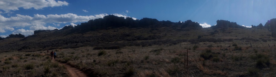
The devil is buried. And his backbone protrudes. You can walk beside it, touching the sides of his massive vertebrae. Chilling? Creepy? Actually it’s a fine spring hike or bike, for you, the kids and the dog.
The burial site can be found just west of Loveland, Colorado on Highway 34, about an hour south of Cheyenne.
One of Larimer County’s Open Spaces, the long and mostly narrow wild park stretches along one of the ridges of the Colorado foothills. And stretch it does. If a person were to walk the length of it they would cover more than nine miles, connecting five named trails. Four of these make narrow loops giving a change of scene.
Most people are content to start at the south end and hike one or two of the loops, climbing up to the backbone’s fins, walking along them to catch the view of this geologic wonder and the peaks beyond. The more ambitious can explore to their lungs’ content.
The northern end, without the backbone’s vertebrae, is popular with mountain bikers who roar along under the cresting wave of red rock. It makes for a good walk, too, if you are prepared to step out the bikers’ way. Deer are plentiful here on the brushy hillsides. Meadowlarks warble in the fields below. Hawks and golden eagles circle the skies.
Science, which so rudely interrupts the thrilling buried-devil folklore with its stark facts, is amazing in its own right. Placards on the Morrison Loop trail tell us that the fins are not bone but sandstone. Sandstone that was deposited about 100 million years ago when tyrannosaurs shook the ground and pterosaurs shrieked through the skies.
This sandstone was elevated when the Rockies were uplifted between 80 and 55 million years ago, with the softer rock eroding over the eons, leaving us this upright view of what was once a level sandy dinosaur playground.
If you go…
At the south end, the Devil’s Backbone Trailhead is off Highway 34, just west of Loveland. Take I-25 south to Highway 34 at the outlet malls, then go west 8.9 miles. Keep an eye out for the brown and white sign on the right marking the turn to the parking area. Parking is free, dogs are welcome, free trail maps are on the sign boards and there drinking water and a privy.
To reach the north end, the Blue Sky Trailhead, take I-25 south to Harmony Road in Fort Collins. Go west on Harmony/CR 38E 12.3 miles. When Harmony crosses Taft Hill it becomes CR 38E. Stay on CR 38E, winding and climbing around the tips of Horsetooth Reservior. The trailhead is on the right just off the road. Parking here will cost you $6. Dogs are welcome, trail maps are available and there is a privy. If the lot is full (it is very popular) you could continue on to the Soderberg Open Space Trailhead and park there, hiking the Inlet Bay Trail back to Blue Sky.
More information, maps and up-to-date trail conditions can be found at www.co.larimer.co.us/parks/parkareas.htm

Comments
Lynn Carlson
Apr 17, 2016
This is near Sylvandale Ranch, I think. Had seen it but didn’t know you could hike there. Thanks for the info and gorgeous photos!