Pole Mountain Surprise: The Death Crotch
The information in this piece may be out of date. I have moved away from Cheyenne and am no longer maintaining this site. You may leave a comment if you wish. Useful comments will continue to be posted.
I thought I knew all the paths of Pole Mountain and Vedauwoo. Prided myself in my superior know-how and know-where. So I was surprised when my friend Shan showed me a map produced by the Pedal House, a Laramie bike shop. It showed a trail called “The Death Crotch” climbing the west side of Pole Mountain.
On a fine spring day I went up to check out this secret. I expected a rough single track, a steep climb up, and a death-to-the-crotch rumble back down. I expected to have it to myself. After all, if I didn’t know about it who would?
I climbed a barbed wire fence and quickly found the trail, marked by a large rock cairn. And there was an elderly couple strolling arm in arm. Then a family of three searching for morel mushrooms under the pines (they weren’t finding any). Two mountain bikers pedaled past. Then two horses and riders walked by! More bikers….
Clearly this trail wasn’t a secret to anyone but me! I asked one of the bikers how long he had known about it. “All my life,” he said.
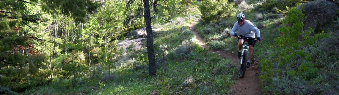
What I found wasn’t a rough track but a well-made old trail, carefully graded to ascend the 600 feet to the top over 1.8 miles. There were hints of an old cowboy camp under an overhang. Perhaps the trail was made by ranchers, the forest service or by the military years ago.
And what I found is perhaps the prettiest route up the mountain, more interesting by far than the well-known Headquarters Trail. There are shady walks under the trees. Openings with views of Turtle Rock and the distant Mummy Range. Flower spangled glades and rocky outcrops.
It’s good in spring, summer and fall. All of the flowering beauties will be there: roses, lupines, showy daisies, sego lilies, sticky geraniums, blanket flowers, yarrow and paintbrush, arnica and pussytoes.
Rare red lilies can be found in glens along Old Happy Jack. If you’re lucky enough to see them, just enjoy. Picking the blossoms prevents seed from setting and reduces their already low numbers. Besides when cut they wilt in no time.
So check out the Death Crotch. Maybe you’ve known of it all your life. Maybe you’ll be surprised, too. I’m glad to be humbled by new wonders in a familiar place. Without humility where would we find the awe?
And if you know why it was named “Death Crotch” or any earlier names for the route let me know at write a comment.
When you try your own Death Crotch trek….
Download a free map from www.pedalhouse.com/maps.php or from Al Walsh’s “Just Trails” site: www.justtrails.com/trails/tie-city-happy-jack/. At Just Trails you can also get a map on your smart phone and use it as a gps, watching your progress and location.
Death Crotch branches off of the Old Happy Jack Road trail. There are three ways to get to it.
The most direct access requires a barbed-wire fence climb-over or crawl-under Take Happy Jack Road from Cheyenne. Past mile post 32 and the right hand passing lanes there is a place on the left with room for a car or two on the dirt. A broad spur trail cuts through the trees. Get past the fence and walk a hundred yards or so to the Old Happy Jack trail. Go to the right and you’ll see a cairn on the left. That’s the start of Death Crotch. The trail is easy to follow and ends at the Summit Loop ski trail on top.
A little longer alternate with no fence to deal with is to start at the south end of Old Happy Jack trail (aka Hootch trail). From Happy Jack Road drive past mile marker 31 and turn left on FS 707. Go 1.2 miles. When the road makes a sharp left make a right turn into a circular parking area. Old Happy Jack starts beyond the metal gate. If you stand at the fire ring you’ll see it. Walk down Old Happy Jack one mile to the cairn on the left and start your ascent.
The third alternate makes for a terrific 7 mile loop hike, up Death Crotch with its sunny views and down the Haunted Forest trail with its shady aspen glades, probably the finest aspens in the area. Start by driving into the Happy Jack Recreation Area, a left turn on FS 719. Continue to the end of the dirt road at the Pole Creek Campground Gate. Park there. Old Happy Jack is beyond the log fence.
Hike along Old Happy Jack by some sparkling beaver ponds. At 8/10ths of a mile you’ll walk across a small creek coming in from the trees. The Haunted Forest trail is a clear tread on the right with no sign. You’ll come out here on the way back. Continue 1.1 miles to the large cairn on the right. This is the start of Death Crotch. Take it to the top. Go right on the Summit Loop, and right again on Summit Trail (aka Vans Loop), then right on Haunted Forest which is marked at this end. Take it down to Old Happy Jack, turning left to get back to your car.

Comments
Tyler
May 5, 2016
Hello, my girlfriend and I really enjoy reading all of your adventures and make it a goal to try most of them. We are students at the university here in Laramie so our hiking time is mostly used up with snow. We enjoy snowshoeing in the winter but in the spring we always want to get out and hike. We constantly plan out hikes around Pole Mountain or Medicine Bow but are cut short due to closed roads and snow-covered trails. We feel our options for a quality hike are limited in the spring months, is this true? Where would you recommend us to go on sunny days like today, yet with some snow cover in the mountain trails? Thank you!
Roger Ludwig
May 16, 2016
Hi Tyler,
The shoulder seasons are tough around here. Spring snow can be messy and we’re often just tired of it and ready for spring. Here’s a few ideas. The first are the trails at Curt Gowdy State Park, just a few miles past Pole Mountain on Happy Jack but it is nearly 1,000 feet lower so it clears far sooner. Many of the trails near the visitors’ center are busy with mountain bikers but the trails closer to Crystal Reservoir are not. There is a new post today on a Crystal Loop and an older post on Hidden Falls and the Chameleon.
There is another area near Laramie that is worth exploring in the spring even though there are no trails there, Sand Creek. There is a post on that one, Sand Creek National Natural Landmark.
After that it means driving into Colorado and hiking some of the Open Space areas of Fort Collins or Larimer County. The closest to Laramie is a beautiful spring spot, the Eagle’s Nest just off of Hwy 287 onto Red Feather Lakes Road.
A spring area that I love is a bit more challenging as it is vast and has no trails or even road signs. Navigation is always tricky up there and I find a GPS necessary. This is the Laramie Peak Wildlife Habitat Management Unit. You would go west on HWY 30 and then take Sybille Canyon Road toward Wheatland, turning off on Tunnel Road. This area is much lower in elevation than Laramie and is often terrific around Memorial Day. In the summer and fall the canyons are full of poison ivy and I avoid it. I’ve written about two areas there, Duck Creek Falls and Reese Mountain. There is a lot to see up there and it is so open you can go almost anywhere. https://wgfd.wyo.gov/accessto/whmas/laramie.asp
The area is popular with climbers and you can read more about it on their posts. https://www.mountainproject.com/v/laramie-peak-wildlife-habitat-management-area/107466817
I have two friends in Laramie who maintain hiking sites. If you aren’t familiar with them check out http://www.JustTrails.com and http://www.HikeLikeAWoman.net
Best wishes to you! I hope we finally get a spring this year! Roger
Mark
Jan 6, 2021
Thanks for sharing this… Love the pictures