Spring and Fall Hikes at Guernsey State Park
The information in this piece may be out of date. I have moved away from Cheyenne and am no longer maintaining this site. You may leave a comment if you wish. Useful comments will continue to be posted.
For spring hikes nothing in southeast Wyoming beats Guernsey State Park. If you think you know the place, popular for its camping, swimming and water skiing, but have never been up on the cliff tops, think again.
During the 1930’s the young men of the Civilian Conservation Corps constructed six interlocking trails that reach from the soaring heights that overlook the Platte Gorge down to the lapping waters of the reservoir itself.
I love these hikes for three reasons. The first—it’s warm! With an altitude of 4,700 feet it is 1,500 feet lower than Cheyenne, 500 feet lower than Fort Collins. Spring gets to Guernsey first. Locals I spoke to hike these trails on pleasant days year round.
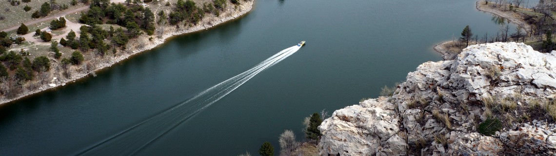
The second–the big view. It’s hard to find a spring hike in the area that really delivers a “Wow!” but these trails do it. Three of them take you along the cliff edge, a 500 foot sheer drop to the blue waters. The sight of the Platte River Canyon, its stunning walls, deep blue waters and side gorges is awesome. Try it at sunset.
And then there are the views all around. The Laramie Range fills the western horizon. At places you can see down into the town of Guernsey and even into the red gash of the old Sunrise Mine.
The third–the marvelous rock construction of the Civilian Conservation Corps. During the 1930’s young men were offered work to provide an income for their families back home. It was at Guernsey that the men proved that they could do more than heavy lifting. They could develop real skill.
Here the stone masonry is a work of art. It was a game changer for the depression era program and men in units all over the country began to build structures of beauty from locally sourced logs and rock.
The most magical and elaborate of their creations is The Castle, a picnic shelter beyond anyone’s fantasy. It’s at one of the trailheads, a must see. Near it is the “Million Dollar Biffy,” a monumental sandstone restroom. The Brimmer Point Overlook, at another trailhead, climbs seamlessly upon the rock. Only when you look closely do you see it is manmade.
Even the trails themselves show true craftsmanship with careful switchbacks and rock stairways.
From the cliff tops…
The limestone floor crunches underfoot, the deposits of ancient salt water. It is everything the sea is not: sharp, hard, brittle and light grey, the ocean’s very shadow self, standing high above today’s fresh waters. Craggy, like a weathered old man, looking down, scoffing even, with his superior wisdom upon the moment’s illusions of permanence. “You’ll be dry and gone before you even know it.”
The vultures in the canyon—well maybe you aren’t fond of vultures with their bald red heads and beady eyes—but at Guernsey you may learn to think again. They soar and slowly wheel, fifteen or more, above and below you, adjusting their spiral with the slightest tip or dip of a feather. And one may glide right toward you at eye level, safely easing above you as you tip back to watch him pass.
Wild turkeys gobble in the canyon bottoms, doves coo in the trees. Locals told me of some very special mule deer on the south side of Powell Mountain.
Sadly a raging fire swept through these canyons in 2012. A fire ban was in place but a couple was determined to toast their wieners. When stopped from doing so in the park they defiantly stepped over the boundary and built their little camp fire. It blew up 2,700 acres, burned over five days and took 233 firemen and 2.3 million dollars to extinguish. They were arrested and jailed just days later.
The dry pine forests are struggling to revive. Sadly there is little shade now and two historic foot bridges were destroyed. Thanks to all who worked so hard to put it out.
The trails
Trail maps are hard to come by. None are available at the park entry. The park ranger sent one to me by mail and I’ve posted it here among the photos at the end. to print them right click on one, click on “save as,” then go to that spot and click to print it. Do the same for the other one and tape them together if you wish and, voila, you have a good trail map. There is also a mapped signboard at Brimmer Point Drive. You could shoot a photo to use as a guide.
My favorite trail is Marsh Mountain, a high 1-mile loop along the cliff tops. I also like the Lakeview Trail because of its variety, starting at a shady grove along at the water’s edge then leading upward through a broad meadow to join the Marsh Mountain loop, 1.1 mile each way.
My recommendation is to start at the Davis Bay Drive trail head and go up Lakeview, do the Marsh Mountain loop and continue on the North Bluff Trail to see “The Castle,” then returning down Lakeview, about 6 miles total.
The Brimmer Point Trail lets you enjoy some of the remaining unburned cool pine and juniper woodland, soft needles underfoot. For a 2.7 mile loop it can be combined with the Newell Bay Trail which cuts through the geology, a few million years of descent through sea floor and sea side sediments.
When you go…
It’s a bit of a drive from Cheyenne, 99 miles, but with no stop signs between town and the fee booth, you’ll make good time, about 1 ½ hours. Take I-25 north past Wheatland to exit 92, then go east on US 26 toward Guernsey. At 14.2 miles turn left at the sign for Guernsey State Park, WY 317. You’ll need to stop at the fee booth to pay $4 for Wyoming cars, $6 for others (bring exact amount as the booths may be unmanned). At the fee both turn left toward Sandy Beach. Just after crossing the deep railroad cut over the bridge turn right toward The Castle.
The next three roads on the right each lead to a trailhead. The first is Brimmer Point Drive where there is a kiosk with a map board. The next is Davis Bay Drive which has a picnic area and pit toilet at the trailhead. The last goes to The Castle, a picnic shelter with toilets nearby.
Dogs are welcome on leash. The trails are open for hikers, mountain bikers and equestrians. They are rocky so hiking shoes rather than sneakers are advised. Carry water and be prepared for sun and wind. Trail signage is poor as the fire took some of them out but the trail tread is visible.
When you are done with your little adventure reward yourself with a drive through Guernsey to Lockman’s Lunch Box on the east edge of town. It’s a classic drive-in with real homemade milk shakes and malts. Enjoy a pepper jack double cheese burger. You’ve earned it!
Post Script: May 24, 2020 There are two good trails that are not on the printed map but are on the sign board. I hiked them today and found them really enjoyable. Peak View Trail (PV) starts near the sign board at the junction of Skyline Drive and Brimmer Point Drive. Look for a small wooden sign that says “trail.” 1.5 miles later it comes to the junction of Newell Bay Trail and Davis Bay Trail. There is enough tread on the ground to follow it and cairns help when you need them. The trail crosses Brimmer Point Drive twice then loops around the long mountain (4701′ on the map). Good for mountain biking, decent views.
Tunnel Mountain Trail (TM) is fun with lots of variety and it is a work out. One trail head is easy to find. When you enter the park continue straight at the fee station. Turn left into the Park Headquarters. You’ll see the trail sign at the end of the parking lot. The other end of the trail is on Skyline Drive, the road that goes left at the Fee Station. The trail head is on the right past the Skyline Drive picnic and camping area but before the railroad bridge. There is an unmarked pull out and parking area in a grassy hollow with a log sign at the trailhead. The TM climbs high to the top of Tunnel Mountain with superb overlooks of the dam and then drops down to a view of the railroad tunnel mouth (Yes, there is a tunnel running completely through this mountain) and comes down to a spot rich with water, cottonwoods, willows and song birds. The trail has seen recent maintenance and is marked with little survey flags, mostly blue but some red, too. It’s 2.5 miles one way. Not suitable for mountain bikes as there are many tight switchbacks.
Another interesting hike in the area is the Quarry Two Track. It is the old road to a quarry where the Civilian Conservation Corp blasted their building stone from a small canyon. Take Skyline Drive toward the Castle. Past Davis Bay Drive the road makes a ninety degree right turn. Just before that turn is a two-track route to the left with a sign “Service Vehicles Only.” Park there and hike the road it. It is a loop so at the Y you can take either left or right. (This road is marked on the map but not as a loop. It is the “R” that goes left at the red 16.) Good for mountain bikes but perhaps a little bumpy for lack of wear.) Distance? Perhaps a mile each way.
There are at least five good trails or routes on the north side of the park off of Lake Shore Drive. But that is for another post…

Comments
Tove Tuntland
Aug 10, 2017
Great pictures, especially the second to last winding lake pic. Where in the park was that taken? I am planning to watch the Solar Eclipse in Guernsey State Park on Aug. 21. I’ll bring my camera, tripod and gear and would love your suggestion on where to set up my viewing station!
Roger Ludwig
Aug 10, 2017
Thanks! Guernsey should be a great place to see the eclipse. Get there early! That photo was taken along the Marsh Mountain trail, #5 on the map, facing east.
Tove Tuntland
Aug 11, 2017
Since you seem familiar with the park – what site would you recommend to experience the eclipse (the sun will be slightly east or middle in the sky) and the water/view together?