A Pole Mountain Secret: the Hidden Trail to Point Crawford
The information in this piece may be out of date. I have moved away from Cheyenne and am no longer maintaining this site. You may leave a comment if you wish. Useful comments will continue to be posted.
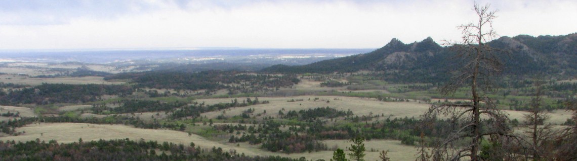
The long ridge line of Pole Mountain slopes several miles from the summit toward Cheyenne ending in a distinct point, Point Crawford. From there it cascades down to ever smaller points until the mountain is finished.
Long ago a walking trail was made leading up to Point Crawford along the gentlest route, rounding these points. That trail still exists, yet it is unmarked and unmapped. Its entry is a hidden secret.
The trail to Point Crawford and beyond to points further north quietly awaits your discovery.
It ascends through ever shifting small landscapes, sage and aspen, pine shadows, rocky outcrops, dry meadows and wet. Windows open to big, ever growing views: Turtle Rock and the Twin Peaks, distant Longs Peak, the mighty Mummy Range, the Medicine Bows and the Snowy Range. There are signs of deer, elk, coyote, and if you walk far enough, Moose. Frogs call in the moist dusk.
Personally, I like a route nearly lost to time. It keeps me alert–for the next rock cairn, the subtle wear of tread, limbs cut for passage, logs and sticks carefully placed by forgotten hands to form a curb, keeping me to the path. I like it when it works, when there is no piece missing. And this one works.
Directions to the hidden entry
Take I-80 west of Cheyenne, WY, to the Vedauwoo exit. At the end of the exit ramp turn left away from Vedauwoo, under the freeway, then right on the service road. A couple of miles later take the first right under the freeway, Forest Service 705, Blair-Wallis Road. Stay on FS 705 past FS 707, Headquarters Road.
One tenth of a mile before you reach Wallis Picnic Ground is a brown fiberglass stake on the right. Cryptically it simply says “Motorized Route Ends.” (I noticed this summer that the sign is now broken off and laying on the ground.) This is the Point Crawford Trailhead. Park off the road.
As you stand facing the stake looking into the woods you’ll see a post topped with a faded yellow sign. That’s the way.
Onward to Point Crawford
The trail starts with a steep up-hill challenge guaranteed to get your heart pumping. It wraps around a natural rock fortress with a clear tread and a few simple cairns marking the way. You’ll come to the first fence–barb wire. Don’t cross it but take the trail to the left.
You’ll reach this fence again but here it is a wooden cross-tree model beginning to fall down. Again, continue to the left without crossing it, passing by another rocky top to your left.
For the third time the trail comes to the fence. Here, in an open saddle, the wooden center portion has been torn out and repaired with barbed wire. Follow the lane made by logs on the ground to the end of the wooden fence. This one you do cross, climbing over the old wooden rail. Look ahead for cairns that guide you past a fire ring. The tread is faint but cairns will lead you across the opening and to the left. The tread re-emerges for another steep uphill push. The trail is badly eroded.
Shortly before the trail’s high point is a tall cairn followed by a second cairn. If you want to go to the top of Point Crawford leave the trail here making your way to the rocky top to the right, a 670 foot elevation gain from the trail head. (GPS UTM 13 T 0467026 / 4562063)
Beyond to the weird and wonderful
The trail continues long beyond Point Crawford, calling you onward as time and energy permit, following the edge of the mountain, west of the well-known Headquarters Trail. After climbing a little from the two cairn passage to the Point the trail drops into the trees. Those who maintained the path years ago often marked it by laying long logs along both sides, creating a lane. Keep an eye out for these particularly where the way may be confusing.
In the saddle beyond Point Crawford stands a strange iron framework, carefully built for some mysterious purpose. An animal trap? (GPS UTM 13 T 0466979 / 4562189) Up on the top of the next hill is an open area where piles a branches and logs have been place. (GPS UTM 13 T 0466824 / 4562782)
Continuing along, hikers are lead to two wet meadows. Both are frequented by moose. The second contains another framework, a tall teepee of poles, probably a hunters’ blind, hidden in a glorious grove of aspen. (GPS UTM 13 T 0460014 / 4564080)
Turning left on a faint trail just beyond the teepee leads to the Beehive, a rock wall heavily used by technical climbers, and on to FS 705JA.
Where does the Point Crawford trail end? I don’t know. I’ve have always run out of time before I ran out of trail. Maybe you’ll discover it. If you do, let me know.
Tips
Some parking is available along the road or there is a large parking lot at the Wallis Picnic Ground, a fee area. There is no drinking water available. A toilet is near the trailhead at the Wallis Picnic Ground.

Comments
RJ Keelan
Jan 17, 2013
Point Crawford Trail
This trail is known as the Upper BC Trail, and very darned few people know about it. I’ve been going on it since 1975, and it’s still pretty much the same as it always was. PLEASE don’t actually show it to anybody. Some of the other “hidden” trails have been “discovered,” and they’re pretty well trashed-out by the bicyclists. There used to be a Yurt-type structure made from thin logs, but it has long-since collapsed, and the Teepee structures you refer to are a fairly recent addition. There are several ways to get onto this trail, and all are quite obscure. The North Entrance is actually pretty obvious … IF you know where to look. In nearly forty years, I’ve only shown four or five others, and I think everyone who knows about it has kept mum as well. One of the bike shops in Laramie published an article in one of the bicycling magazines about the bike trails, and has even sponsored a race (anything to make a buck!), and the parking lots are now full of “greenies” — maybe you’re one of them — and the trails are trashed. If Cacarado is so freaking great, then stay there!
Roger Ludwig
Jan 18, 2013
Ow. Sorry you are so angry. My purpose in writing is simple. I’ve learned that if wild places are to be preserved there have to be people who, like you, care about them.. Of course people only care about places they have been to and enjoyed. It’s true that I now want people to go–to hike, to enjoy and to advocate for wild places.
I once wanted to keep great places secret. (When it comes to fishing holes I still do.) But one of my favorite, and perhaps the wildest place in Southeast Wyoming, Reese Mountain, was about to be purchased from the Forest Service and BLM by a wealthy real estate developer for his own private use. Thankfully we were able to rally support, largely through the newspaper, and he stopped his efforts. The Wyoming Range was about to be drilled recently but enough people banded together to stop it, and now to even buy back the leases. Sadly the red desert, including Adobe Town and Honeycomb Buttes is not getting enough of the same advocacy. I’ve learned that if places are kept secret they will, sooner or later, be destroyed.
With respect to Coloradans, it is hard to see some hiking trail heads full of green plates. I’ve lived in Wyoming for only 21 years so am not a native. But I like to hike in Colorado and have been all over their northern wilderness areas and have never experienced prejudice as a “bucking horse”. The damage I’ve seen in Pole Mountain (and there has been a lot of it) has been by locals on ATV’s, irresponsibly cutting new trails, dropping all kinds of trash and shooting out of season. If people are going to use our outdoors they have to learn how to do it with care no matter where they are from.
If I haven’t pissed you off to much with my preaching, do you know why it is called the “BC Trail”? If you’ve never been up to Reese Mountain I hope you go.
Roger
J. Allen
Feb 10, 2013
Thanks for the great write-up. I’ve been looking for places around Laramie to enjoy the wilderness that are quieter then Vedauwoo and not quite as far as the Med-Bow hike. The directions for driving lost me (I’m bad at that), can you elaborate on how to get there from the other side, coming out of Laramie? And don’t worry about me ruining the trail, I’m just looking for a quiet walk in the woods every once in a while–rest assured I will be discreet in whom I share it with.
Roger Ludwig
Feb 10, 2013
Sure. From Laramie take I-80 to the Summit Rest Area exit. As you exit go left toward the rest area (where the Lincoln Head is) but don’t turn into the rest area. Pass it by. The asphalt road will turn to gravel and you will begin to head down hill. This is Blair-Wallis Road, Forest Service 705. You will pass a parking area on your left. That is the trail head for the Headquarters Trail, another nice get away that is the subject of another post. Keep going down hill. You will pass the Wallis Picnic Ground on your right. That is your signal to pull to the side of the road and look for the fiberglass sign or the post off at the edge of the trees. Snow will keep the road closed though until spring.
J. Allen
Feb 12, 2013
Ah, very nice, thank you very much. I’m sorry to hear that it will remain closed for some months–do you have any suggestions for other accessible places close to Laramie this time of year?
Roger Ludwig
Feb 12, 2013
How about snowshoes? You may want to try a pair, small ones that can be rented for a day, and go up to the Tie City or Happy Jack Winter Recreation area trailheads. There are many trails there that are well packed. Here’s a link to the area winter map: http://mbna.pbworks.com/w/page/6898933/Grooming%20Information The purple and red trails are perfect.
You also may want to ask folks at the Cross Country Connection store in Laramie. They might have some winter hiking ideas.
David Q.
Jun 9, 2013
My dog and I hiked the first portion of this trail last Thursday during a week in Wyoming. It was one of my best days out. Like you, I enjoyed the incredible views and the sense of exploration as I searched out the trail. I could add some additional tips to finding the trail head directions, but I don’t want to make it too easy to find. BTW: if you lost a handheld GPS unit, post here with the brand and color, and I’ll get it back to you. It must have been very recently lost as it worked perfectly when I turned it on. I also now know of a few more places to hike because of it!
Shan Holyoak
Oct 14, 2014
Actually, the trail you describe, at least the beginning of it, used to be on a forest service trails map. But, I never “found” it as I was looking for a more obvious trailhead. Will now be able to hike this trail. Incidentally, I have hiked parts of this trail but thought that it ended up on FR 707. I found it by accident one day hiking cross-country from the Headquarters Trail. At times the only way to tell that you are on trail is that downed trees across the trail have been cut. I know that we are discussing the same trail as I have seen the metal frame in your pictures. I to have wondered its use. I figured a hunters blind.
Shan Holyoak
Oct 16, 2014
Hiked this trail end-to-end today.
Susan Oliver
Apr 15, 2015
I walked part of this trail with my husband yesterday. A friend told us about it. We could’t find the starting point, so picked the path up by heading upward from the trailhead walk further along. We visit Laramie each year and love the hiking. This is a special trail.
Sheila
Jun 14, 2015
Gorgeous trail. I call a portion of it Double Black Diamond. I have accessed it from the BeeHive , Escape Trail and also from 707. I have never accessed it from the trail to Point Crawford but I have seen the sign you described. How exciting to find a new spot. I have seen a bunch of moose on it in the fall, 7 or so. I agree no one seems to know about it and I appreciate a new approach to get to it. Thanks for the interesting posts.
Steve Kaminski
Dec 27, 2015
In regards to the metal framework;
I am not sure but back in the eighties I ran across similar frames with netting. The local university had it tagged as some type of botanical experiment. It could possibly be a remnant of such an experiment. The netting was used to keep animals from eating the plants.
Dan Kline
Jul 23, 2016
I don’t know about super secret; I’ve seen the trail on at least two maps online. Even if the trail is “discovered”, I don’t think you’re going to get a bunch of mountain bikes on this route. The connection to the Headquarters Trail winds up in a bog, and the east termini are simply too rugged. Other comment, it’s easy to get off the path once you’re a mile or so in. I did a little bit of wandering and cussin trying to find an alignment to walk on up there more than once. But then again, the joy is in the journey.
Wayne Karberg
Jul 28, 2017
A Group of 21 seniors from Laramie (Seniors on the GO, out of the Eppson Center), hiked up to Point Crawford today. A new hike for us that we enjoyed!