Boars Tusk: By any other name….
The information in this piece may be out of date. I have moved away from Cheyenne and am no longer maintaining this site. You may leave a comment if you wish. Useful comments will continue to be posted.
Give it a more captivating name and this ancient volcanic plug just might be a tourist destination.
How about the Black Cathedral or perhaps Druid’s Throne? It is dark, mysterious, a weathered old ruin rising on a circular dais, jabbing the heavens, more ready to curse than bless…
Or the Dark Flame? That captures its shape and color, echoing its birth, a blast of intense heat, an eye-blinding scream of molten rock erupting from the ground two and half million years ago…
It truly is a Hawk’s Aerie. I saw her perched, then soar, then the dive into the sage. She labored off with a limp rabbit rising heavily to her nest on the spire, blood marking the ground.
But the trappers called it Boar’s Tusk. And so Boars Tusk it became. And the snaggle-tooth of an old boar is what we see. Pity. With imagination and the ever changing light a person can envision so much else in this strange jut of rock.
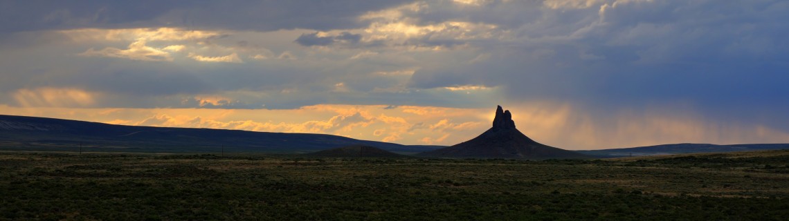
Driving down from Rock Springs in the evening it looked like an industrial ruin, a crusher with stacks, grey cloud imitating smoke.
Wanting to catch photos at sunset and dawn I threw down a little tent in the sand near its base. The sun set in a grey gloom. The desert so quiet I thought I could hear the hum of the universe. Somewhere in the distance wild burros brayed goodbye to the day.
At midnight I looked out to see a whirling sea of stars, the tusk a black hole against the sky. It promised to be a fine morning.
First light brought the twitter of little brown birds. Antelope quietly grazed. Walking along a sandy two-track to the old plug the 400-foot tusk became more and more impressive, looming above. Swallows wheeled, rabbits and ground squirrels were busying themselves in the brush, the prickly pear, the dark grasses.
In a burst of light the sun leaped above the eastern hills, the tusk casting a huge shadow. I was glad I came. The scramble to the top of the cone-shaped base beats coffee to get the heart pumping. What a view over the big anything-but-empty!
And the day was just beginning.
Beyond the tusk are the Killpecker Sand Dunes, more than 50,000 acres of shifting sand, windblown into waves and ripples and huge swells that call for a sliding clamber to their crest. It’s a beach in search of a sea.
Between the dunes are basins large and small sporting grasses and occasional pools of snowmelt, quenching the thirst of desert elk.
The western portion is managed as wilderness. You can walk and roll and relish the silence and the solitude.
The eastern portion is the “open play area.” Here helmeted riders roar past on dirt bikes, catching air as they crest the dunes at full throttle, relishing their skill and speed. ATV’ers were getting some lift, too.
I love this America. We really do our best to manage wildlands so everyone including the elk has what they enjoy.
Now when it comes to naming places, consider Killpecker Dunes, named from Killpecker Creek, the drainage that flows south from the dunes to Rock Springs.
Legend tells of soldiers assigned to protect the Overland Stage station in the 1860’s. After drinking the salty water of the creek, then known as Kilpatrick, they discovered their virility had been compromised. In the long tradition of military humor they renamed it Kill Pecker creek. And so Killpecker it became.
My advice? Bring your own water.
Then before you leave investigate the White Mountain Petroglyphs, a site held sacred by Shoshones, Arapahos and Utes. Up a footpath into an area sheltered from the wind is a curving white wall of sandstone. Incised are the etchings of Native Americans reaching back hundreds of years, perhaps a thousand. You’ll peer into the record of ancient elk and bison hunts, horses and riders. At least one warrior holds a threatening sword overhead.
Small handprints are scooped into the rock making a very human connection to those families who camped here long ago.
When you go….
From Rock Springs take WY 191 north. In about nine miles turn right on CR 17, the Tri-Territory Road. Within two miles 17 veers north. The Boars Tusk is in the distance.
You’ll come to the petroglyph site first. A BLM sign marks the west turn on BLM 4120. There is a broad parking area at the end of the road with a vault toilet.
To reach the Boars Tusk and the Sand Dunes Wilderness Study Area continue on CR 17 then turn north on A-17. With a four-wheel drive you can drive close to the base of the tusk on a deeply rutted, very sandy two track. Or you may want to play it safe, park on A-17 and walk in. A trail circles the tusk and a steep route climbs the base.
The wilderness area is beyond the tusk. Continue on A-17 until you reach the powerlines. Find the best place to pull over. Hike to the west as far as you wish.
For the motorized Open Play Area continue on CR 17 turning north on BLM 4115. Go a mile to the parking area. There is a campground with vault toilets.
I found the BLM’s “Rock Springs” map useful as these roads aren’t on my GPS navigator. It’s $4 at the BLM office on 5353 Yellowstone Avenue in Cheyenne.
Once you leave Rock Springs there are no services, no gas stations and no water.
Now, while you’re In Rock Springs stop for a retro treat at the 50’s era Broadway Burger Station, 628 Broadway Street. Great burgers and shakes made the way a shake should be made with real scoops of ice cream.
And who can go through Rawlins without a Mexican meal at Rose’s Lariat? 410 E Cedar Street, Rawlins. At both small places expect a crowd.
