Cottonwood Draw Falls: Not for everyone
The information in this piece may be out of date. I have moved away from Cheyenne and am no longer maintaining this site. You may leave a comment if you wish. Useful comments will continue to be posted.
This waterfall isn’t for everyone. It’s out of the way. On no maps. Not that big. And it requries a real bushwack to reach. Plus it’s seasonal, flowing well only during the wet spring. But waterfalls with a sheer drop are rare in our part of the state. So for waterfall aficionados I’ll let you in this little-known hideaway.
A wonderful old timer, Glen Weber of Wheatland, told me of this fall years ago. He was raised on the flats above, grew wheat and pastured cattle in the badlands of the chalk-rock rim. One summer day I took a long walk through his place coming to the lip of the falls from above. Only a steady drip dropped over the edge of a pour off.
I wanted to come back during a wet spring and we certainly have one now. So I set off to find a route in from the bottom.
It is near Grayrocks Reservoir, on the State’s Cottonwood Draw/Grayrocks Wildlife Habitat Management Area. The turn is well marked and a gravel road dead ends at a parking area. From there a clear trail leads up the creek, the falls about 1-¼ map miles ahead.
Soon the trail leads into the creek bed and disappears. I enjoyed walking along the bed, up one side and then across to the other, following deer trails. Then I found myself in a pygmy forest of juniper, a Wyoming jungle of jabbing branches, downed trees and grape vines. Rocks like concrete aggregate had to be climbed over and circled around. All is bathed in the humid scent of honeysuckle, choke cherry and muddy waters.
There was a steady flow in the creek now, gurgling over rocks and into pools before moving on to be swallowed by the sand. I flicked a tick off my jeans.
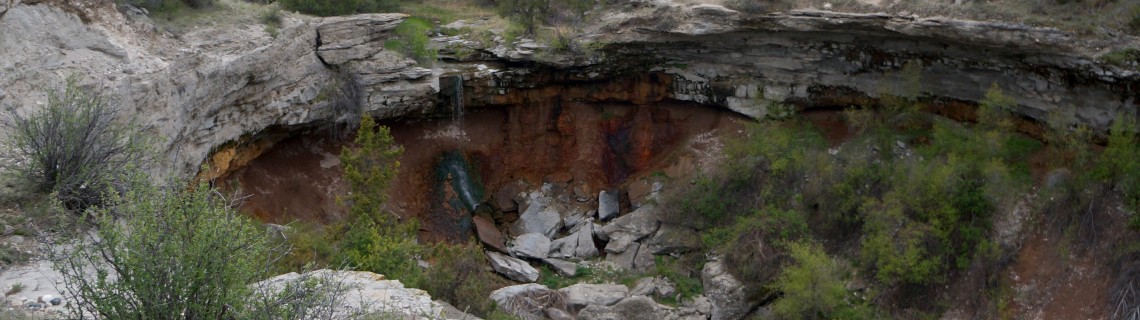
The draw, broad at first, steadily narrows until it forms a U-shaped box of gray rock cliffs with steeply slanted sides. And at the end is the fall.
A stream of water pours off the sharp edge, drops through open air to land on a sloping bed of verdant green moss before disappearing in the jumble of boulders. A line of additional dribbles sparkles in the sun to the right. The spray and slope require some slippery maneuvers to scale above the trees to reach the very end.
Cottonwood Draw Falls drops about 15 feet. Photos I’ve seen from early spring show a long run of naturally sculptured ice under the overhang.
I like this chalk rock country of gray cliffs.
The rock looks like concrete, an aggregate of round river stone cemented in a silvery matrix. Geologists call it the Gering Formation of the Arikaree Group. The matrix contains volcanic ash from Yellowstone explosions 25 million years ago.
Standing on a flat slab, transported back in time, I envisioned myself on the plain in the falling ash. Herds of early camels, horses and rhinos stampeded to the east to escape. Sabertooth tigers and hyaenodons-huge hyena like predators-ran as well. Oreodonts, ruminating hogs, hustled to their underground burrows, not knowing that they would be suffocated in their beds.
Back in the present I spied a way up the cliffs back from the falls on the east. Climbing up I found that the creek has its origin about a half mile up stream in a spring, the water emerging into a round hole in the creek bed.
These upper pastures of wildly eroded badlands are fantastic landscapes, strange and mythical.
So if not for everyone, who is it for?
Older kids and teens may enjoy the search for the fall if they are willing scramble and get dirty, forming a miniature corps of discovery. Restless fishermen might like it on days when the walleye aren’t biting.
Those who love the quiet trickle of a hidden waterfall pouring over silent rocks, breathing life to a powder dry country, filling the air with fragrant chokecherry perfume, would find a well-earned respite. It’s a good place to munch a sandwich and peel an orange.
Now that I’ve seen it flow I want to come back earlier in the spring when ice grasps the walls, forming white fanciful sculptures.
To go….
Take I-25 north past Wheatland, getting off at exit 80. Go east, making a left turn to avoid the curve into town. At the “T” go north (CR 320), then follow the signs to Grayrocks Reservoir taking Grayrocks Road to the right. Your route will take you past the power plant and then up to the reservoir.
When you pass an empty store and gas station on the right keep your wits about you. There will be a brown and white sign reading “Cottonwood Draw/Grayrocks Wildlife Habitat Mgmt Area.” Past the sign, on the right, is the turn off. Take the gravel to the loop at the end. Your adventure begins through the gap in the fence.
The walk in to the falls can take 45 minutes to an hour. A map is available at https://wgfd.wyo.gov/accessto/Whmas/cottonwood.asp
There are no facilities at the trailhead. Vault toilets can be found at camping areas near the reservoir.
For another take on Cottonwood Draw check out this interesting blog from “In the Company of Plants and Rocks.” http://plantsandrocks.blogspot.com/2015/03/the-crystal-unicorn.html

Comments
Charlie
Jan 29, 2017
How severe is the current of Cottonwood Draw Creek in the mid summer.
Roger Ludwig
Apr 4, 2017
The creek below the falls typically dries up by late June.
Ken
May 23, 2017
Is there an abundance of turkey in the area?
Roger Ludwig
May 23, 2017
I don’t know. I didn’t see any during the times I have been there. Roger