Rawah Lakes
The information in this piece may be out of date. I have moved away from Cheyenne and am no longer maintaining this site. You may leave a comment if you wish. Useful comments will continue to be posted.
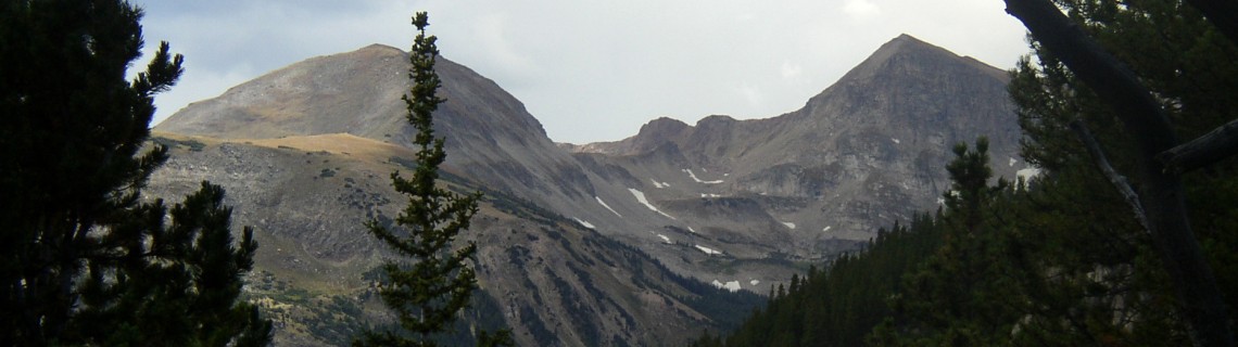
Highlights: An overnight circle-on-a-stick backpack into the high alpine country we see on the far southwestern horizon from Cheyenne, Wyoming: the southern Medicine Bows. Here, above tree line, twelve pristine lakes sparkle in the shadow of North and South Rawah Peaks. Rawah is pronounced Ray’-wah and is a native American word meaning “wild place.”
Location: The Medicine Bow range south of the border in Colorado
Elevations: West Branch trailhead 8, 580’; high point at Grassy Pass, 11,220’
Distance: 19.3 miles without the spur trails
Maps: Rawah Wilderness by Mountain Jay Media; Arapaho and Roosevelt National Forests; USGS quad Rawah Lakes; Roosevelt National Forest pamphlet “Rawah Wilderness”
Guide: Raymond Ave’s Backcountry Adventure Guide to Colorado’s Rawah Wilderness
is an excellent guide to it’s trails, history and geography.
Trailhead: From Cheyenne, take I-80 west 48 miles to Laramie exit 311. Go southwest on WY 230 24 miles to Woods Landing. Then take WY 10 south 34 miles (In Colorado it is County Road 103) until you come to the well-marked West Branch parking area. (An alternative would be to go to Ft. Collins, go west on CO 14 then north on CR 103.)
The Hike: The trail starts in the meadows and aspens of the Laramie River Valley. Follow the West Branch of the Laramie River into the Rawah wilderness on trail 960 through deep timber. The route hovers well above the laughing waters below. At 3.7 miles turn right on Rawah Trail 961. After 1.8 miles there is a spur trail that leads 1.3 miles to gorgeous Twin Crater Lakes. The lakes are above tree line in a mat of tundra sheltered by a massive rock bowl scooped from the Medicine Bow range.
Back on Rawah Trail 961 continue northwest to the high point of Grassy Pass. The views here are heavenly and the climb will produce more than enough endorphins to really enjoy it. High peaks stretch north and south. The Rawah lakes are like blue and green gems sprinkled into the landscape. Coming down from the pass is a joy. You can count down the Rawah Lakes, beginning with number four, down to one.
There are many good camping areas to pick from. Regulations require a 200 foot distance from lakes and steams to prevent destruction of the sensitive vegetation.
To complete the loop turn right on Camp Lake Trail 968. At Lower Camp Lake another spur trail leads .7 miles to big Upper Camp Lake, a peaceful wonder of quite and solitude. The Camp Lake Trail gets long and hot. For a couple of miles it follows the lip of an abandoned irrigation ditch then plunges steeply down the forested mountain side past a couple of ruined cabins to join the West Branch trail. Turn east to return to the trailhead.
Pointers: These high alpine areas are not heavily used, probably because the hike to them is typically 7 up-hill miles. As an alternative to backpacking, many take a trailer or a tent to the Tunnel Campground and make a long day hike to Twin Crater Lakes, Grassy Pass or to Lower and Upper Camp Lakes. As you might expect, prepare for mosquitoes and bright sunshine.

Comments
Leah
May 19, 2015
Hi there Roger, thanks for this and all your great posts. They have sparked the flame of many a memorable adventure! Always amazed at all there is to explore from our Cheyenne home base.
Wondering how early in the season the trails in this post are snow free. Looking for a short weekend trip destination first weekend in June, 8 miles from car to campsite or thereabouts, preferably at a lake or stream…
Roger Ludwig
May 20, 2015
You are looking at a very early season trip. The Rawah’s would not be good. The trails that reach the lakes would not be snow free until the start of July probably. And we are having a very wet May with fresh snow in all the high country around here. I would consider a low altitude trip. In the Vedauwoo area the meadows on the north side of Twin Mountain are nice but only a couple of miles in. For that trail check out my friends at http://www.JustTrails.com. Seaman Reservoir would certainly be open. See my page on Gateway Natural Area in Colorado. If you are up to a longer drive and would like a desert experience June could be a good time for Adobe Town, Honeycomb Buttes, Boars Tusk and Killpecker Dunes, all in the Red Desert Area. I have never written a post on them but you can find info online and at the BLM office in Cheyenne where you could also get maps.
I am wondering about Comanche Peak wilderness, hiking from Comanche Reservoir to Comanche Lake. This area is also off of Colorado 14 but turning south to Pingree Park. Hike Beaver Creek Trail to Comanche Lake Trail. These folks are the Comanche Wilderness experts: http://www.joeandfrede.com/comanche.htm They say mid-June for Comanche Lake.
Here is another online map: http://www.ouachitamaps.com/picture_library/Comanche%20Peak/Comanche%20Crown%20Map.jpg I’d call the Forest Service (970-295-6700) to see if the area is open before I would drive up.
Roger Ludwig
May 23, 2015
Leah, after thinking about it a little more I have two other ideas for you. The North Laramie River Trail to the old Rainbow Inn is a terrific early summer spot, perhaps in a different direction than you might have been considering. It’s in the Laramie Range west of Wheatland. The other is the Encampment River Trail starting at the north end. It is also at a fairly low elevation. In some years the wild flowers in the sage section are stunning. There are posts for both of these trails here. Roger
Leah
May 25, 2015
Wow, what great suggestions, Can’t thank you enough, Roger!
Dave Lalande
Sep 3, 2015
Hello, thanks for the knowledge. I was wondering if you knew if it’s easier to come from Blue Lake and meet up with trails #961/968 and then to Upper Camp or start at Tunnel Camp ground? I’m going to Blue Lake this weekend with my kids and then going to do a solo next week to Upper Camp.
I thought of doing the solo to Upper Camp starting at Tunnel but I see on the map that I could go up part Blue Lake to #961. Since I’m already going to be 5 miles in at Blue Lake I don’t know if it’s be easier just to keep going?
Any words of wisdom would be much appreciated.
Thanks again for the information.
Dave
Roger Ludwig
Sep 3, 2015
Dave, I love Upper Camp Lake. Should be a good trip either way. Tunnel Campground to Upper Camp is 8.2 miles. Blue Lake trailhead to Upper Camp is 15.3. So even from Blue Lake, at roughly 5 miles in, it is closer from Tunnel. But once you are at Blue Lake you have gained most of your altitude, except for the climb up to Blue Lake Pass. I’m wondering where you would leave you vehicle? If it was at Blue Lake Trailhead there is no question that Tunnel Campground is the easiest, with only a 8.2 mile walk out compared to 15.3 back to Blue Lake TH. If you could leave it at Tunnel and get a ride to Blue Lake Trailhead for the hike in with your kids it is a toss up. Going over Blue Lake Pass is definitely more scenic. The walk in from Tunnel is mostly in the pines. Have a good trip! Roger
Kyle
Dec 24, 2019
Great Info !!
A few buddies and I are planning on a backpacking trip to the Rawah Wilderness in mid July. We don’t have a choice July or August, etc. Just happy we could all get the same vacation time off. We are planning on starting on the West branch trail and going counter clockwise doing the Camp Lake Loop. We will be there several days (taking our sweet time. We are all in our 50’s, want to do it nice and slow ). We are doing 4 nights.
Do you have any suggestions for the best camping areas? I have seen almost of suggestions, but you seem to have an in depth knowledge of the area.
Thanks for any thoughts or ideas. Really looking forward to heading out there. It’;s been a looooong time.
Kyle