Leapfrogging the Teton Crest
The information in this piece may be out of date. I have moved away from Cheyenne and am no longer maintaining this site. You may leave a comment if you wish. Useful comments will continue to be posted.
The Teton Crest Trail draws trekkers from all over the world. It’s one of the top ten alpine hikes anywhere, Switzerland, New Zealand and Patagonia included. But it hadn’t drawn me. Something got in the way.
Permits. I’m from Wyoming. I like my freedom. I want to camp where I want to camp when I want to camp. Can’t do that in Teton National Park. I like free entry to my wilderness. Can’t do that in Teton National Park. Twenty five dollars at the gate.
But the Teton Crest Trail runs the high line behind the mighty peaks. It drops over a divide through the plunging canyons, spilling out at their feet. I had to set aside my pride and belly up to the bar, the bar being the counter that is the backcountry desk of the Senator Thomas Visitor Center at Moose. I hate to admit it but the staff was more than pleasant and patient. Blond, pretty and knowledgeable.
She smelled good, too, which was a heavenly contrast to the hitchhiker I had picked up in Dubois and had just dropped off on the highway.
The Confusing Beginning
Just where does the Teton Crest Trail begin? Well, there is no real agreement on it. Maps and guidebooks pick three different trailheads that all, after a day’s pack, converge on Moose Divide. Most Cresters cheat, taking the tram from Teton Village, cutting off a 2,000 foot climb.
Call me many things, and people have, but I’ve never been one to do anything the easy way. No cheating for me. But which trailhead?
She looked over my plans and lined me up with the premier campsites, spaced over the days I had to hike. No problem. No charge. All trailheads are in the Caribou-Targhee National Forest so no permit was needed for my first two nights.
She explained that for groups of six or less permit reservations are rarely needed, even during the peak season from the end of July through August. Just come in to the backcountry desks at the Moose Visitor Center and they should be able to work something out. But if your crew is seven or larger the group sites are required. They are rare and popular. Need to apply for a permit between January 5th and May 15th, the sooner the better. The reservation fee is $25.
Bear canisters are required, a black plastic keg for grub and anything that smells good to bears. I understand that if a grizzly comes across one they bat it about, growing frustrated enough to attack the humans that made their piñata so hard to open. Well, at least I didn’t have to hang anything from trees.
She issued me one for the hike, no charge. Wow. Said I should have an ice axe to traverse the last remains of a snow field. To rent that I needed to go back to Dornan’s just up the road. $30 for my six nights. Ouch.
I drove down the road to trail’s end. There is agreement on where the tail stops. It’s at the String Lake parking lot just past the Jenny Lake Lodge. I was crossing my fingers, hoping to hitch to one of the three trailheads, about 35 miles away.
It was hot. The sun simmered. A cow elk and two calves browsed at the edge of the parking lot. The peaks towered above, unreal in their glory. I prayed I had gained some good hitch-hiking karma back in Dubois when I picked up the smelly guy from New Orleans. But the blond at the desk had also handed me a list of companies that would shuttle me for a fee if I was only making up for karma I’d lost due to some fool thing I’d done. Looking me over, I knew she thought I’d need it.
I started asking people in the lot for a ride. Only locals, County 13 plates, had room in their rigs. The tourists all looked like the Clampetts headed to Hollywood, only in SUVs. No problem. First local I talked to said he’d take me to the highway. A park employee who restores historic log buildings, he told me that the trail definitely started at the Middle Fork of Phillips Canyon north of Wilson off County Road 3. He dropped me off at Moose.
I started asking County 13 plates for a ride. Second one pulled over. A rafting guide, buff and bronzed, headed to his newly wed wife after a hard day’s work. He pointed out a coyote working a field, an osprey nest in a cottonwood snag. No the trail definitely starts at the North Fork of Phillips Canyon west of Wilson off Wyo 22 as we whizzed by the turn off to Wilson. .
He dropped me at Highway 22. I pointed my thumb west. Second car pulled over. A school teacher and his little boy, commuting from Driggs. His passion was backcountry skiing. Climb up and zoom down. No the trail starts at Coal Creek just over Teton Pass as we whizzed by the North Fork trailhead.
Well, that’s decided. I’m hiking in at Coal Creek, the longest of the three “no cheaters here” routes. It was dusk as I headed up the trail, looking for a flat place to pitch my tent beyond earshot of the road.
In the Wilderness
I was really here, in the Jedediah Smith Wilderness, five days, six nights of solo tromping, 38 miles of trail stretching before me. I stamped down the weeds enjoying my freedom to pick a tilted campsite that could roll me in the creek. All my food wouldn’t fit in the bear canister. Oh, well, I slung the rest over a tree.
To people who rate hikes, the Miss America pageant judges of America’s wild beauty, the Teton Crest is usually awarded the first runner up mountain hike in the US, second only to the much longer 211 mile John Muir Trail in California’s Sierra Nevada’s. It is praised for it’s wildlife and wildflowers, cascades and lakes, fine campsites and, of course, its spectacle-bursting beauty. I found all of that plus an astounding change of scene — social and spectacle — with each of the seven sections.
The first leg, from Wyo 22 to Moose Divide, is in that small slice of Wyoming with the most precipitation per year. It also has shallow soils over a limestone pan. Poor for trees but perfect for flowers, acres of them, often thigh high. Sticky Geraniums. Lupine. Columbines. And, except for the occasional moose, solitude. Few people cover this ground. They are missing something special, especially at July‘s end.
Leg two, day two begins on the divide, a tundra walk through a carpet of flowers, now in miniature. The mighty Grand Teton makes his first appearance, hovering on the horizon like a mirage. The granite crag is strange and out of place, for this is karst contrary, great limestone bowls and cliffs, gently tilted sediments forming mighty plateaus.
Marion Lake nestles like a jewel between pines and stony rampart, a shady rest stop in the center of this section. Widely spaced hikers are usually now visible, the cheaters, coming up from the ski lift. Spearhead Peak pierces the blue.
Death Canyon Shelf
At Fox Creek Pass the world changes again as the trail leads on to Death Canyon Shelf. Here we walk along a broad, flat shelf of limestone, one long cliff towering on the left, the gorge of Death Canyon a shear drop to the right. Waterfalls soar from the cliff tops, run across the shelf and plunge into holes, tunneling under our feet to explode from the canyon walls below us.
For three and a half miles we walk the wonderful shelf. I’ve joined a father and daughter from Illinois. He hiked it as a college student and is now sharing these scenes from his dreams with her. She’s loving it, calling out flower names from her guide as we eat lunch.
The story goes that Death Canyon was named by Thomas Bannon‘s 1899 survey party. One of their members wandered into the canyon, never to return. They guessed he suffered death by grizzly or Shoshone. Maybe he just found it too beautiful to leave?
Camping on the shelf is a highlight. Two deer walk through camp. A marmot visits. The great canyon expands below. And now the Tetons are all visible, jutting upward.
It’s strange to be walking on these limestone sea beds. They seem shy, embarrassed, even confused. Apologetic Limeys, ‘Pardon me mate, don’t really know what I’m doing here, got pushed up by something you know. Should be miles under water…”
In contrast the Tetons are wild men, cocky and brash, cooked in the fiery cauldrons of inner earth, the new upstarts of the Rocky Mountain chain. They own this earth. Their granite has had little time for the polishing of glaciers. They are ragged and rip-roaring, like guys that are fun to hang around with but are frightening to invite home. But before entering their domain we enter the fourth leg.
The Party
At Mount Meek Pass the shelf ends and we descend into Alaska Basin, a fantastic broad sculpted bowl with a tilted granite floor. And people! People everywhere! I’ve walked out of the cathedral hush into a fraternity house on Saturday night. Brave and stupid young men strip to their skivvies and plunge into the icy Basin Lakes as their wiser brothers cheer from the sides. Young women scope them out. “Ah, now who is the fittest?”
Alaska Basin is outside of the National Park. There are no limits, few rules. About anything goes. To say the place is the craze of Idaho youth groups is a gross understatement. Didn’t think I’d say it, but “Bless the NPS permit system.” It cuts the crowds and gives some serenity to the rest of the trip.
As much as I am mesmerized by the scenery, this granite with a hint of salmon, peppered with pines, ringed by ridges and peaks, I’m overwhelmed by people and noise. I hustle my way through, up, down and around this great place. At little Sunset Lake the trail begins a steep open ascent and the crowd melts away.
A Perennial Hurricane
Up and up, a young married couple from Pennsylvania and I are leapfrogging now, passing each as the other stops to rest. This is the pull to Hurricane Pass. The mighty Grand begins as a point of rock, growing above us as we hike higher, and then, boom! If a sight can shout, this is it. The Tetons are right here, the whole group of them, brazen and proud. We’re high enough to look them right in the eye.
The wind is blowing so that it’s hard to stand yet we spread out like specks on the vast saddle to sit and breathe it in. At one time or another every hiker walks carefully to the edge, peering down into the canyon. Far below the bright white Schoolroom Glacier curves into a turquoise pool. This view, this place, this wonder is what has brought us. We have found glory.
Finally the wind and the call of camp push us off the rim, dropping into the heart of the range, down jarring switch backs into the South Fork of Cascade Canyon and an altogether new scene.
Up there we were exposed. Now we are nestled. Great mountains rise high above us, towering pines surround. The creek is frolicking, rushing as it is joined by waterfalls and spray falling in tendrils from on high. My neck cranes to follow their line to the brilliant sky.
Some people suppose that hiking in solitude allows the mind to fill with great and profound thoughts. In truth it’s a little different. By day two the brain is a bit numb, a tired yellow sponge just taking it in. Sometimes it’s even hard to remember things. Things like your name. And where you are from.
And then there is the annoying song, playing over and over, the same short phrase, the same stupid snippet. Why DID I listen to the “Sultans of Swing“ (“We are the Sultans, the Sultans of Swing, du dute du…”) on the way over? There is no getting rid of it. The best that can be done is to find a replacement and that often doesn’t stick. But here I had some luck, putting in a Christian rock song, “There is such a thing as glory, glor-ee…”
What glory, this holy, verdant canyon! Descending and descending some more, refreshed, heading to the forks, the junction with Cascade Creek. The junction is also the chief goal for day hikers following the most popular trail in the park, coming up from Jenny Lake and Inspiration Point.
The Meeting Place
For four days all the people I’ve seen are trail worn, whiskered and unwashed. Whatever color our baggy clothes were at the start they are now primarily trail-dust brown, as is our hair, our skin, hats and packs.
And then fuchsia! Lime! Cadmium Orange! Inhabiting these colors are sporty Europeans, sullen grousing teens, tired kids, moms and dads — the one who thought of this excursion chippy and skippy, the other dragging dourly along behind.
Somewhere I smell fresh oranges. An Italian family was eating bananas. I nearly swooned, laying down in the dust. Looking up the trees seemed to be coming together. A few deep breaths. Time to go on, mouth watering, unquenched. I should have asked. But they had looked at me like something the cat dragged in.
The next leg, up the North Fork of Cascade Creek, is dedicated to one thing: homage to the Grand. He’s constantly in view, standing tall with his consorts, Mt. Owen and Teewinot. The creek runs straight to him and the canyon is wide open. Even the canyon’s scenic end, Solitude Lake, serves to reflect the master mountain himself.
Then there is another long pull, a steady cut up the far wall to Paintbrush Divide. A new trail companion helped the time pass. A lawyer from Albuquerque, Dave was with a group of guys from all over the country. They join up for one week-long backpacking trip per year and have been doing it for nearly twenty. We talked of places we both had been and places we want to go, of injuries and family and of how that group had come to be together.
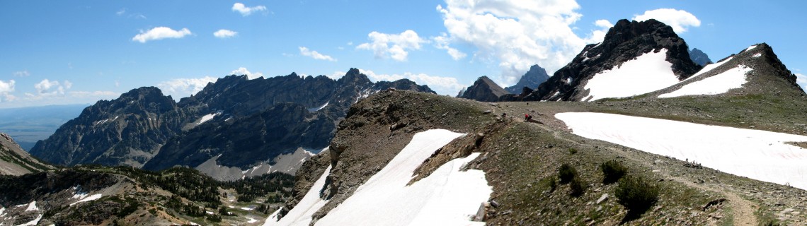
The Divide is another explosion of scope and scale. From its rim we stare down into three canyons, Cascade behind us, Leigh to the left and Paintbrush, where we are headed, to the right. Peaks all around. The ragged ridge of “The Jaw” pulls the eye.
Hikers below are moving ants. Even along this divide we are spaced so far apart that we disappear into the rock. Why is it we feel so good when we see we are so small?
A snowfield below must be crossed. Everyone is a bit tense. This is why I have been lugging a five pound ice axe, yet even with it not confident in my ability to arrest my fall down a thousand foot slope. The trail here is a slight trough in a mountain of unstable scree. A few hand holds are needed to make the turns.
Approaching the steep snow I see that a Ranger has come up this morning with a shovel and has dug out the path. It’s a cake walk. Further snowfields can be stomped to stability.
Cocktails on the Green at Five
Now the last leg, down Paintbrush with an overnight at Holly Lake. Looking down canyon our eyes go to the shimmering sapphire surfaces of Leigh and Jackson Lakes. Blue, ephemeral, filling the valley’s “v” sight.
As I set up camp I see I’m joined by new friends, Dave’s group through the trees and the leapfrogging young couple near the meadow. I’m invited for cocktail hour at precisely five, BYOB. We talk, drink, laugh and laugh some more. One of them has carried a bottle of wine the whole way for this moment. I sip the last of my Jim Beam.
Holly Lake is beautiful, hanging up here on a shelf. Ancient white bark pines reach skyward, The Jaw glows orange, the line of light rising up and up and up until the last peak glows like a candle. Poof! The first stars shine. Just six miles to the truck in the morning.
Walking along String Lake I pause to watch a long cord of folks crossing it on horseback, some smiling, others serious, a few terrified. The horses know where they are going. My truck smells of dust after sitting for five days.
Driving out I pull into Climbers Ranch for one of the area’s luxuries, a five dollar shower, no membership required. Refreshed, scrubbed and in clean clothes I head to lunch on the patio at Dornan’s.
Sitting with a beer and a steak midst the crowds, looking up at the Tetons’ familiar front, all I could think about was how much there was “in back”. What I really wanted to do was restock at the grocery, go to the desk and ask the nice blonde ranger for a new permit, this time to walk into Death Canyon and see what kept that surveyor all these years. I think I know.
Useful Info
Grand Teton National Park
Backcountry Information and Reservations: (307) 739-3602
Web site: http://www.nps.gov/grte/
Map
Trails Illustrated “Grand Teton National Park”
Guidebooks
-
Hiking Grand Teton National Park, a Falcon Guide
by Bill Schneider
-
Jackson Hole Hikes
by Rebecca Woods

Comments
Jake Willits
May 15, 2011
Fantastic! I’m so glad you posted this. I have always been interested, but had been convinced that the Wind River Range might be a better option because of the required permits. My buddies dislike treks managed by the NPS. Again, thanks!
Sue Ladan
Feb 4, 2013
I am getting through the wet Pacific Northwest winter by occasionally looking at pictures of the Teton Crest Trail. My husband and I did most of it last summer, and hope to do it again this year, only starting at the Coal Creek TH and going out over Paintbrush Divide. We have been hiking all over for years, and this hike definitely “ruined” us for most others. We, too, were hesitant about a permit system hike, but we found the same as you: only a friendly, helpful Ranger.
Tracey
Jul 20, 2018
Gosh, you managed to not only authentically describe your trip, but also answer a ton of questions I had about doing this trail, the conundrum as to where it starts, where can you shower as well as the history, the flowers and geology and the other hikers you met. Truly a wonderful piece of writing and incredibly helpful in my personal trip planning! Thanks so much!
Eric
Apr 13, 2019
Hiked this trail last summer from Phillips Canyon. Your words capture the trail perfectly… the beauty, the thoughts I had while hiking, the interactions with other people at various places along the trail.
Last summer, I made it to Lake Solitude and decided I couldn’t make it up Paintbrush Divide. I turned back and went out Cascade Canyon instead.
I re-read your post today because I’ve decided to go back this summer and hike it again. This time I’m going to “cheat” and take the tram. But I’m confident that an easier first day will allow me to get over Paintbrush Divide this year. Thanks for inspiring me to give it another go!
Gary
Jan 29, 2021
Driving up to coal Creek trailhead adds hiking distance, but it also eliminates a lot of vertical you get when you start the hike in the valley…. So driving up is similar to those “cheaters” who take the tram…. Interesting